Back Ternopil-oblast Afrikaans مقاطعة ترنوبل Arabic Óblast de Ternópil AST Ternopol vilayəti Azerbaijani Тернополь өлкәһе Bashkir Цярнопальская вобласць Byelorussian Тарнопальская вобласьць BE-X-OLD Тернополска област Bulgarian Ternopiljska oblast BS Província de Ternòpil Catalan
Ternopil Oblast
Тернопільська область | |
|---|---|
| Ternopilska oblast[1] | |
|
| |
| Nickname(s): Тернопілля (Ternopillia), Тернопільщина (Ternopilshchyna),
Галичина (Halychyna) | |
 | |
| Coordinates: 49°33′21″N 25°35′33″E / 49.55583°N 25.59250°E | |
| Country | |
| Administrative center | Ternopil |
| Government | |
| • Oblast council | 64 seats |
| • Chairperson | Viktor Ovcharuk (Petro Poroshenko Bloc) |
| Area | |
| • Total | 13,823 km2 (5,337 sq mi) |
| • Rank | Ranked 22nd |
| Population (2022)[2] | |
| • Total | |
| • Rank | Ranked 21st |
| GDP | |
| • Total | ₴ 82 billion (€2.120 billion) |
| • Per capita | ₴ 79,412 (€2,057) |
| Time zone | UTC+2 (EET) |
| • Summer (DST) | UTC+3 (EEST) |
| Postal code | 46-49 |
| Area code | +380-35 |
| ISO 3166 code | UA-61 |
| Raions | 3 |
| Cities (total) | 14 |
| • Regional cities | 1 |
| Urban-type settlements | 17 |
| Villages | 1019 |
| FIPS 10-4 | UP22 |
| Website | www.adm.gov.te.ua |
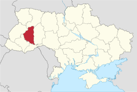
Ternopil Oblast (Ukrainian: Терно́пільська о́бласть, romanized: Ternopiľśka oblasť), also referred to as Ternopilshchyna (Ukrainian: Терно́пільщина, romanized: Ternopiľščyna) or Ternopillia (Ukrainian: Тернопі́лля, romanized: Ternopilľa), is an oblast (province) of Ukraine. Its administrative center is Ternopil, through which flows the Seret, a tributary of the Dniester. Population: 1,021,713 (2022 estimate).[2]
One of the natural wonders of the region are its cave complexes.[4] Although Ternopil Oblast is among the smallest regions in Ukraine, over 100 caves have been discovered there.[4] Scientists believe these are only 20% of all possible caves in the region.[4] The biggest cave is Optymistychna Cave.[4] Measuring 267 km (166 mi) in total length, it is the longest cave in Eurasia and the fifth-longest in the world.[4] Twenty percent of the land in the region is chernozem soil.[4]
Among its attractions, Ternopil Oblast has 34 castles.[4] By at least one account, the most prominent is the Zbarazh Castle with fortifications that expand over 16 ha (40 acres) and was the center of a 17th-century standoff between troops of Bohdan Khmelnytsky and the army of the Polish–Lithuanian Commonwealth.[4] The Dniester Canyon passes through the oblast; it is considered one of the wonders of Ukraine, stretching for 250 km (160 mi).[4]
- ^ Syvak, Nina; Ponomarenko, Valerii; Khodzinska, Olha; Lakeichuk, Iryna (2011). Veklych, Lesia (ed.). Toponymic Guidelines for Map and Other Editors for International Use (PDF). scientific consultant Iryna Rudenko; reviewed by Nataliia Kizilowa; translated by Olha Khodzinska. Kyiv: DerzhHeoKadastr and Kartographia. p. 20. ISBN 978-966-475-839-7. Archived (PDF) from the original on 2021-01-25. Retrieved 2020-10-06.
{{cite book}}:|website=ignored (help) - ^ a b Чисельність наявного населення України на 1 січня 2022 [Number of Present Population of Ukraine, as of January 1, 2022] (PDF) (in Ukrainian and English). Kyiv: State Statistics Service of Ukraine. Archived (PDF) from the original on 4 July 2022.
- ^ "Валовии регіональнии продукт".
- ^ a b c d e f g h i Tell about Ukraine. Ternopil Oblast Archived 2020-11-01 at the Wayback Machine. 24 Kanal (youtube).
© MMXXIII Rich X Search. We shall prevail. All rights reserved. Rich X Search

