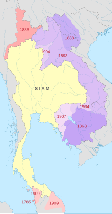
The territorial losses of Thailand is a concept in Thai historiography, referring to conflicts during the Rattanakosin era of Thailand (or Siam as it was historically known) where the country was forced to cede territory, especially to the Western powers of France and Great Britain during the reign of King Chulalongkorn (Rama V, 1868–1910).
The concept was popularised in the 1930s as part of the Thai nationalism promoted by the government of Plaek Phibunsongkhram. The idea was propagated through sets of maps, titled the Historical Atlas of Thailand and Map of the History of Thailand's Boundary, that claimed to depict the historical extent of the boundaries of Thailand's predecessor states and the territories it subsequently lost. The maps have been widely disseminated, especially through their inclusion in Thongbai Taengnoi's student atlas, a standard textbook used in Thai schools since 1963.
While later historians have questioned the maps' historical accuracy, the concept remains a mainstay in Thai nationalist discourse, and has re-emerged especially during episodes of the Preah Vihear Temple dispute with Cambodia.
© MMXXIII Rich X Search. We shall prevail. All rights reserved. Rich X Search
