Back Гансхорен Bulgarian Ganshoren Breton Ganshoren Catalan Ganshoren CEB Ganshoren German Ganshoren Esperanto Ganshoren Spanish Ganshoren Estonian Ganshoren Basque گانشوران Persian
Ganshoren | |
|---|---|
 Ganshoren's Municipal Hall | |
| Coordinates: 50°52′N 04°19′E / 50.867°N 4.317°E | |
| Country | |
| Community | Flemish Community French Community |
| Region | Brussels-Capital |
| Arrondissement | Brussels-Capital |
| Government | |
| • Mayor | Jean-Paul Van Laethem (ProGanshoren) |
| • Governing party/ies | ProGanshoren, LB, DéFI |
| Area | |
| • Total | 2.44 km2 (0.94 sq mi) |
| Population (2020-01-01)[1] | |
| • Total | 25,234 |
| • Density | 10,000/km2 (27,000/sq mi) |
| Postal codes | 1083 |
| NIS code | 21008 |
| Area codes | 02 |
| Website | ganshoren.be/fr (in French) ganshoren.be/nl (in Dutch) |
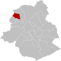
Ganshoren (French: [ɡansɔʁœn, -ʁɛn], Dutch: [ˈɣɑnsˌɦoːrə(n)] ⓘ) is one of the 19 municipalities of the Brussels-Capital Region, Belgium. Located in the north-western part of the region, it is bordered by Berchem-Sainte-Agathe, Jette, and Koekelberg, as well as the Flemish municipality of Asse. In common with all of Brussels' municipalities, it is legally bilingual (French–Dutch).
As of 1 January 2022[update], the municipality had a population of 25,252 inhabitants.[2] The total area is 2.44 km2 (0.94 sq mi), which gives a population density of 10,376/km2 (26,870/sq mi).[2]
- ^ "Bevolking per gemeente op 1 januari 2020". Statbel.
- ^ a b "Ganshoren | IBSA". ibsa.brussels. Retrieved 5 January 2023.
© MMXXIII Rich X Search. We shall prevail. All rights reserved. Rich X Search


