Back ياغودينا Arabic Ягодзіна BE-X-OLD Ягодина (град) Bulgarian Jagodina BS Ягодина (Серби) CE Jagodina (kapital sa distrito) CEB یاگۆدینا CKB Jagodina Czech Jagodina Danish Jagodina German
Jagodina
Јагодина (Serbian) | |
|---|---|
| City of Jagodina | |
|
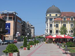
From top: City Center, Church of St. Peter and Paul, Courthouse, Museum of Jagodina, Museum of Naïve and Marginal Art, Artificial waterfall, Town square | |
| Etymology: Strawberry (Serbian: Јагода) | |
 Location of Jagodina within Serbia | |
| Coordinates: 43°58′N 21°15′E / 43.967°N 21.250°E | |
| Country | |
| Region | Šumadija and Western Serbia |
| District | Pomoravlje |
| City status | December 2007 |
| Settlements | 53 |
| Government | |
| • Mayor | Ratko Stevanović (JS) |
| • Ruling parties | JS-SPS-PUPS |
| Area | |
| • Urban | 470 km2 (180 sq mi) |
| Elevation | 111 m (364 ft) |
| Population (2022)[2] | |
| • Administrative | 64,644 |
| • Urban | 34,892 |
| • Urban density | 153/km2 (400/sq mi) |
| Time zone | UTC+1 (CET) |
| • Summer (DST) | UTC+2 (CEST) |
| Postal code | 35000 |
| Area code | +381(0)35 |
| Car plates | JA |
| Website | www |
Jagodina (Serbian Cyrillic: Јагодина, pronounced [jâɡodina] ⓘ) is a city and the administrative center of the Pomoravlje District in central Serbia. It is situated on the banks of the Belica River, in the geographical region of Šumadija. The city itself has a population of 34,892 inhabitants, while its administrative area comprises 64,644 inhabitants.
- ^ "Municipalities of Serbia, 2006". Statistical Office of Serbia. Retrieved 2010-11-28.
- ^ "2022 Census of Population, Households and Dwellings: Ethnicity (data by municipalities and cities)" (PDF). Statistical Office of Republic Of Serbia, Belgrade. April 2023. ISBN 978-86-6161-228-2. Retrieved 2023-04-30.
© MMXXIII Rich X Search. We shall prevail. All rights reserved. Rich X Search


