Back Матагуа Byelorussian Мотагуа (река) Bulgarian Riu Motagua Catalan Río Motagua (suba, lat 15,72, long -88,24) CEB Motagua Czech Мотагуа CV Río Motagua German Río Motagua Spanish Motagua Finnish Motagua French
| Motagua River | |
|---|---|
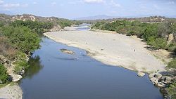
 The Motagua River during the dry season | |
 The Motagua River, flowing from the highlands in western Guatemala to the coast at the Guatemala–Honduras border | |
| Location | |
| Countries | Guatemala and Honduras |
| Physical characteristics | |
| Source | Quiché Department |
| • coordinates | 14°56′57″N 91°00′32″W / 14.94917°N 91.00889°W |
| • elevation | 1,800 m (5,900 ft) |
| 2nd source | Baja Verapaz Department |
| Mouth | Gulf of Honduras in the Atlantic Ocean |
• location | Puerto Barrios |
• coordinates | 15°43′29″N 88°13′18″W / 15.72472°N 88.22167°W |
• elevation | 0 m (0 ft) |
| Length | 486.55 km (302.33 mi)[1] |
| Basin size | 12,670 km2 (4,890 sq mi)[1] |
| Discharge | |
| • average | 208.7 m3/s (7,370 cu ft/s)[1] |
The Motagua River (Spanish pronunciation: [moˈtaɣwa]) is a 486-kilometre-long (302 mi) river in Guatemala. It rises in the Western Highlands of Guatemala and runs in an easterly direction to the Gulf of Honduras. The Motagua River basin covers an area of 12,670 square kilometres (4,890 sq mi) and is the largest in Guatemala.
The Motagua River valley contains sources of jadeitite, which has been used by many Indigenous communities that have inhabited the region. The Motagua River is also one of the most plastic-emitting rivers in the world, contributing around two percent of global plastic pollution emissions into oceans annually. Conservation efforts have been driven by the government and non-government organizations to ensure safe water and clean oceans.
© MMXXIII Rich X Search. We shall prevail. All rights reserved. Rich X Search