Back Berlin-Lichtenberg Breton Lichtenberg (Berlín) Catalan Lichtenberg (bahin nga lungsod) CEB Berlin-Lichtenberg German Lichtenberg (kvartalo de Berlino) Esperanto لایشتنبرگ (لوکالیتی) Persian Berlin-Lichtenberg French ליכטנברג HE Lichtenberg (Berlino) Italian Lichtenberg (ortsteil) NB
Lichtenberg | |
|---|---|
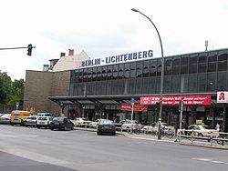
 Lichtenberg railway station | |
| Coordinates: 52°31′16″N 13°28′48″E / 52.52111°N 13.48000°E | |
| Country | Germany |
| State | Berlin |
| City | Berlin |
| Borough | Lichtenberg |
| Founded | 1230 |
| Area | |
| • Total | 7.22 km2 (2.79 sq mi) |
| Elevation | 52 m (171 ft) |
| Population (2020-12-31)[1] | |
| • Total | 41,359 |
| • Density | 5,700/km2 (15,000/sq mi) |
| Time zone | UTC+01:00 (CET) |
| • Summer (DST) | UTC+02:00 (CEST) |
| Postal codes | (nr. 1103) 10365, 10367 |
| Vehicle registration | B |

Lichtenberg (German: [ˈlɪçtn̩ˌbɛʁk] ) is a quarter (Ortsteil) of Berlin in the homonymous borough (Bezirk) of Lichtenberg. Until 2001 it was an autonomous district with the localities of Fennpfuhl, Rummelsburg, Friedrichsfelde and Karlshorst.
- ^ "Einwohnerinnen und Einwohner im Land Berlin am 31. Dezember 2020" (PDF). Amt für Statistik Berlin-Brandenburg. February 2021.
© MMXXIII Rich X Search. We shall prevail. All rights reserved. Rich X Search


