Back مقاطعة ريتشلاند (لويزيانا) Arabic Richland Parish, Louisiana BAR রিচল্যান্ড পারিশ, লুইসিয়ানা BPY Richland Gông (Louisiana) CDO Ричленд (кӀошт, Луизиана) CE Richland Parish CEB Richland Parish, Louisiana Welsh Richland Parish German Parroquia de Richland Spanish Richlandi vald Estonian
Richland Parish | |
|---|---|
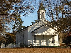
 Alto Presbyterian Church | |
 Location within the U.S. state of Louisiana | |
 Louisiana's location within the U.S. | |
| Coordinates: 32°25′18″N 91°45′43″W / 32.421736°N 91.762070°W | |
| Country | |
| State | |
| Founded | September 29, 1878 |
| Named for | Fertile (rich) land in the area |
| Seat | Rayville |
| Largest town | Rayville |
| Area | |
| • Total | 576 sq mi (1,490 km2) |
| • Land | 559 sq mi (1,450 km2) |
| • Water | 9.375 sq mi (24.28 km2) 1.6% |
| Population (2020) | |
| • Total | 20,043 |
| • Density | 35/sq mi (13/km2) |
| Time zone | UTC−6 (Central) |
| • Summer (DST) | UTC−5 (CDT) |
Richland Parish is a parish located in the North Louisiana Delta Country in the U.S. state of Louisiana, known for its fertile, flat farmland, cane brakes, and open spaces. The parish had a population of 20,043 at the 2020 United States census.[1] The name Richland was chosen due to the rich production from farming. The parish seat and largest community is Rayville.
- ^ "Census - Geography Profile: Richland Parish, Louisiana". Retrieved January 22, 2023.
© MMXXIII Rich X Search. We shall prevail. All rights reserved. Rich X Search