Back نهر اوس ARZ Ouse (Sussex) Catalan River Ouse (suba sa Hiniusang Gingharian, Inglatera, East Sussex) CEB Afon Ouse (Sussex) Welsh River Ouse (Ärmelkanal) German Rivero Ouse (Sussex) Esperanto Río Ouse (Sussex) Spanish رود اوز، ساسکس Persian Ouse (joki Sussexissa) Finnish Ouse (Sussex) French
| Ouse | |
|---|---|
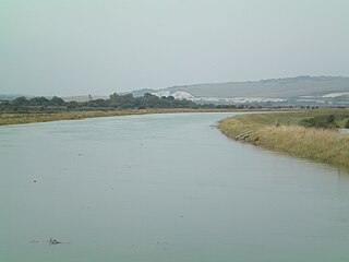
 View looking north towards Cliffe at high tide from Southease swing bridge | |
| Location | |
| Country | England |
| Counties | West Sussex, East Sussex |
| Towns/Cities | Slaugham, Lindfield, Newick, Isfield, Barcombe, Lewes, Newhaven |
| Physical characteristics | |
| Source | |
| • location | Lower Beeding, West Sussex, UK |
| • coordinates | 51°02′20″N 0°14′04″W / 51.038875°N 0.234315°W |
| • elevation | 85 m (279 ft) |
| Mouth | English Channel |
• location | Newhaven, East Sussex, UK |
• coordinates | 50°47′03″N 0°03′29″E / 50.784217°N 0.057995°E |
• elevation | 0 m (0 ft) |
| Length | 35 miles / 56 kilometres |
River Ouse, Sussex route map | |||||||||||||||||||||||||||||||||||||||||||||||||||||||||||||||||||||||||||||||||||||||||||||||||||||||||||||||||||||||||||||||||||||||||||||||||||||||||||||||||||||||||||||||||||||||||||||||||||||||||||||||||||||||||||||||||||||||||||||||||||||||||||||||||||||||||||||||||||||||||||||||||||||||||||||||||||||||||||||||||||||||||||||||||||||||||||||||||||||||||||||||||||||||||||||||||||||||||||||||
|---|---|---|---|---|---|---|---|---|---|---|---|---|---|---|---|---|---|---|---|---|---|---|---|---|---|---|---|---|---|---|---|---|---|---|---|---|---|---|---|---|---|---|---|---|---|---|---|---|---|---|---|---|---|---|---|---|---|---|---|---|---|---|---|---|---|---|---|---|---|---|---|---|---|---|---|---|---|---|---|---|---|---|---|---|---|---|---|---|---|---|---|---|---|---|---|---|---|---|---|---|---|---|---|---|---|---|---|---|---|---|---|---|---|---|---|---|---|---|---|---|---|---|---|---|---|---|---|---|---|---|---|---|---|---|---|---|---|---|---|---|---|---|---|---|---|---|---|---|---|---|---|---|---|---|---|---|---|---|---|---|---|---|---|---|---|---|---|---|---|---|---|---|---|---|---|---|---|---|---|---|---|---|---|---|---|---|---|---|---|---|---|---|---|---|---|---|---|---|---|---|---|---|---|---|---|---|---|---|---|---|---|---|---|---|---|---|---|---|---|---|---|---|---|---|---|---|---|---|---|---|---|---|---|---|---|---|---|---|---|---|---|---|---|---|---|---|---|---|---|---|---|---|---|---|---|---|---|---|---|---|---|---|---|---|---|---|---|---|---|---|---|---|---|---|---|---|---|---|---|---|---|---|---|---|---|---|---|---|---|---|---|---|---|---|---|---|---|---|---|---|---|---|---|---|---|---|---|---|---|---|---|---|---|---|---|---|---|---|---|---|---|---|---|---|---|---|---|---|---|---|---|---|---|---|---|---|---|---|---|---|---|---|---|---|---|---|---|---|---|---|---|---|---|---|---|---|---|---|---|---|---|---|---|---|---|---|---|---|---|---|---|---|---|---|---|---|---|---|---|---|---|---|---|---|---|---|---|---|---|---|---|---|---|---|---|---|---|---|---|
| |||||||||||||||||||||||||||||||||||||||||||||||||||||||||||||||||||||||||||||||||||||||||||||||||||||||||||||||||||||||||||||||||||||||||||||||||||||||||||||||||||||||||||||||||||||||||||||||||||||||||||||||||||||||||||||||||||||||||||||||||||||||||||||||||||||||||||||||||||||||||||||||||||||||||||||||||||||||||||||||||||||||||||||||||||||||||||||||||||||||||||||||||||||||||||||||||||||||||||||||
The Ouse (/uːz/ OOZ) is a 35 miles (56 kilometres) long river[1] in the English counties of West and East Sussex. It rises near Lower Beeding in West Sussex, and flows eastwards and then southwards to reach the sea at Newhaven. It skirts Haywards Heath and passes through Lewes. It forms the main spine of an extensive network of smaller streams, of which the River Uck is the main tributary. As it nears the coast it passes through the Lewes and Laughton Levels, an area of flat, low-lying land that borders the river and another tributary, the Glynde Reach. It was a large tidal inlet at the time of the Domesday book in 1086, but over the following centuries, some attempts were made to reclaim some of the valley floor for agriculture, by building embankments, but the drainage was hampered by the buildup of a large shingle bar which formed across the mouth of the river by longshore drift.
In 1539, a new channel for the entrance to the river was cut through the shingle bar, and meadows flourished for a time, but flooding returned and meadows reverted to marshland. The engineer John Smeaton proposed a solution for the drainage of the valley in 1767, but it was only partly implemented. William Jessop surveyed the river in 1788, and produced proposals to canalise the upper river above Lewes, and to radically improve the lower river. The Proprietors of the River Ouse Navigation were created by Act of Parliament in 1790, and eventually built 19 locks, to enable boats to reach Upper Ryelands Bridge at Balcombe. Trustees and the Commissioners of the Lewes and Laughton Levels jointly managed the work on the lower river, and the agriculturalist John Ellman continued the progress while he was Expenditor for the Commissioners, which enabled 120-ton ships to reach Lewes by 1829. Navigation on the upper river could not compete with the railways, and all traffic had ceased by 1868.
On the lower river, Newhaven became an important port and barge traffic continued using the river up to Lewes until the 1950s. Cross-Channel ferries still sail from the port. The river provides habitat for many varieties of fish, including unusually large sea trout that swim up the river to spawn in the higher tributaries. The Lewes Brooks area of the levels is a Site of Special Scientific Interest because of its wide variety of invertebrates. Walkers can follow the course of the river by using the Sussex Ouse Valley Way long-distance footpath, and the Sussex Ouse Conservation Society promotes awareness of the navigation by publishing details of shorter walks. The Sussex Ouse Restoration Trust is hoping to see navigation restored to the upper river, but this is not universally popular, as the Ouse and Adur Rivers Trust is opposed to the idea.
- ^ "River Ouse". Sussex Angling Media. Archived from the original on 23 November 2021. Retrieved 23 January 2021.
© MMXXIII Rich X Search. We shall prevail. All rights reserved. Rich X Search