Back Vogese Afrikaans Vogesen ALS Vosgos AN جبال الفوج Arabic Cordal de los Vosgos AST Вагезы Byelorussian Вагезы BE-X-OLD Вогези Bulgarian वॉसजेज Bihari Vojoù Breton
| Vosges | |
|---|---|
 Bussang, a commune in the Vosges with a population of about 1,600 | |
| Highest point | |
| Peak | Grand Ballon |
| Elevation | 1,424 m (4,672 ft) |
| Dimensions | |
| Length | 120 km (75 mi) |
| Area | 5,500 km2 (2,100 sq mi)up to 6,000 km2 (2,300 sq mi) depending on the natural region boundaries selected |
| Naming | |
| Native name |
|
| Geography | |
| Country | France |
| Region | Grand Est, Bourgogne-Franche-Comté |
| Range coordinates | 48°N 7°E / 48°N 7°E |
| Geology | |
| Orogeny | Medium mountain range |
| Age of rock | Gneiss, granite and vulcanite stratigraphic units: about 419–252 mya Bunter sandstone stratigraphic unit: 252–243 mya |
| Type of rock | Gneiss, granite, vulcanite, sandstone |
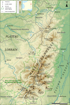
The Vosges (/voʊʒ/ VOHZH,[1][2][3] French: [voʒ] ⓘ; German: Vogesen [voˈɡeːzn̩] ⓘ;[4] Franconian and Alemannic German: Vogese) are a range of medium mountains in Eastern France, near its border with Germany. Together with the Palatine Forest to the north on the German side of the border, they form a single geomorphological unit and low mountain range of around 8,000 km2 (3,100 sq mi) in area. It runs in a north-northeast direction from the Burgundian Gate (the Belfort–Ronchamp–Lure line) to the Börrstadt Basin (the Winnweiler–Börrstadt–Göllheim line), and forms the western boundary of the Upper Rhine Plain.
The Grand Ballon is the highest peak at 1,424 m (4,672 ft), followed by the Storkenkopf (1,366 m, 4,482 ft), and the Hohneck (1,364 m, 4,475 ft).[5]
- ^ "Vosges". The American Heritage Dictionary of the English Language (5th ed.). HarperCollins. Retrieved 17 February 2019.
- ^ "Vosges" (US) and "Vosges". Lexico UK English Dictionary. Oxford University Press. Archived from the original on 5 March 2020.
- ^ "Vosges". Merriam-Webster.com Dictionary. Retrieved 17 February 2019.
- ^ "Vogesen | Rechtschreibung, Bedeutung, Definition". Duden online (in German). Retrieved 17 February 2019. or Wasgenwald
- ^ IGN maps available on Géoportail
© MMXXIII Rich X Search. We shall prevail. All rights reserved. Rich X Search
