Back مقاطعة وارين (كنتاكي) Arabic وارن بؤلگهسی، کنتاکی AZB Warren County, Kentucky BAR Уорън (окръг, Кентъки) Bulgarian ৱারেন কাউন্টি, কেন্টাকি BPY Warren Gông (Kentucky) CDO Уоррен (гуо, Кентукки) CE Warren County (kondado sa Tinipong Bansa, Kentucky) CEB Warren County, Kentucky Welsh Warren County (Kentucky) German
Warren County | |
|---|---|
 Warren County Justice Center in Bowling Green | |
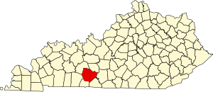
 Location within the U.S. state of Kentucky | |
 Kentucky's location within the U.S. | |
| Coordinates: 36°59′N 86°25′W / 36.99°N 86.42°W | |
| Country | |
| State | |
| Founded | December 19, 1796 |
| Named for | Joseph Warren |
| Seat | Bowling Green |
| Largest city | Bowling Green |
| Area | |
| • Total | 548 sq mi (1,420 km2) |
| • Land | 542 sq mi (1,400 km2) |
| • Water | 6.0 sq mi (16 km2) 1.1% |
| Population (2020) | |
| • Total | 134,554 |
| • Estimate (2023) | 142,229 |
| • Density | 250/sq mi (95/km2) |
| Time zone | UTC−6 (Central) |
| • Summer (DST) | UTC−5 (CDT) |
| Congressional district | 2nd |
| Website | www |
Warren County is a county located in the south central portion of the U.S. state of Kentucky. As of the 2020 census, the population was 134,554,[1] making it the fifth-most populous county in Kentucky. The county seat is Bowling Green.[2] Warren County is now classified as a wet county after voters approved the measure in 2018. The measure became law in January 2019 that allows alcohol to be sold county wide.[3]
Warren County is included in the Bowling Green, KY Metropolitan Statistical Area. It is located in the Pennyroyal Plateau and Western Coal Fields regions.[4]
- ^ "State & County QuickFacts". United States Census Bureau. Retrieved June 28, 2022.
- ^ "Find a County". National Association of Counties. Retrieved June 7, 2011.
- ^ "Wet & Dry Counties in Kentucky" (PDF). Kentucky Office of Alcoholic Beverage Control. Archived from the original (PDF) on March 15, 2007. Retrieved March 21, 2007.
- ^ "Warren County, Kentucky - Kentucky Atlas and Gazetteer". www.uky.edu.
© MMXXIII Rich X Search. We shall prevail. All rights reserved. Rich X Search