Back Blackburn Afrikaans Blackburn AN بلاكبرن Arabic بلاكبرن ARZ Blackburn AST Blekbörn Azerbaijani Блэкберн Byelorussian Блэкбэрн BE-X-OLD Блекбърн Bulgarian Blackburn Catalan
| Blackburn | |
|---|---|
| Town | |
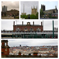
 From top left: Blackburn Town Hall and its extension, Blackburn Cathedral, St Silas' Church, Blackburn railway station and Skyline of Blackburn with St Silas' Church and Masjid E Ghousia | |
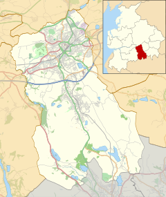
Location within Lancashire | |
| Population | 120,500 [1] |
| • Density | 11,114/sq mi (4,291/km2)[2] |
| Demonym | Blackburnian |
| OS grid reference | SD685277 |
| • London | 184 mi (296 km) SSE |
| Unitary authority | |
| Ceremonial county | |
| Region | |
| Country | England |
| Sovereign state | United Kingdom |
| Post town | BLACKBURN |
| Postcode district | BB1, BB2 |
| Dialling code | 01254 |
| Police | Lancashire |
| Fire | Lancashire |
| Ambulance | North West |
| UK Parliament | |

Blackburn (/ˈblækbərn/ ⓘ) is an industrial town and the administrative centre of the Blackburn with Darwen borough in Lancashire, England. The town is north of the West Pennine Moors on the southern edge of the Ribble Valley, 8 mi (13 km) east of Preston and 21 mi (34 km) north-northwest of Manchester.[n 1][4] Blackburn is the core centre of the wider unitary authority area along with the town of Darwen. It is the second largest town (after Blackpool) in Lancashire.
At the 2011 census, Blackburn had a population of 117,963,[2] whilst the wider borough of Blackburn with Darwen had a population of 150,030.[5] Blackburn had a population of 117,963 in 2011,[1] with 30.8% being people of ethnic backgrounds other than white British.[6]
A former mill town, textiles have been produced in Blackburn since the middle of the 13th century, when wool was woven in people's houses in the domestic system. Flemish weavers who settled in the area in the 14th century helped to develop the woollen cottage industry.[7] The most rapid period of growth and development in Blackburn's history coincided with the industrialisation and expansion of textile manufacturing.
Blackburn's textile sector fell into decline from the mid-20th century and subsequently faced similar challenges to other post-industrial northern towns, including deindustrialisation, economic deprivation and housing problems. Blackburn has had significant investment and redevelopment since 1958 through government funding and the European Regional Development Fund.[8]
- ^ a b UK Census (2011). "Local Area Report – Blackburn Built-up area sub division (E35000757)". Nomis. Office for National Statistics. Retrieved 15 December 2019.
- ^ a b "KS01 Usual resident population: Census 2011, Key Statistics for urban areas". National Statistics. Office for National Statistics. Archived from the original on 7 September 2009. Retrieved 9 July 2008.
- ^ "Authorities: AGMA Policy and Research Unit". Association of Greater Manchester Authorities. Archived from the original on 18 October 2015. Retrieved 11 May 2010.
- ^ "Grid Reference Finder". Gridreferencefinder.com.
- ^ Census 2001: Blackburn with Darwen Local Authority, Office for National Statistics. Retrieved 28 March 2008.
- ^ "Blackburn.gov.uk – Ethnicity and Religion profile" (PDF). Archived from the original (PDF) on 26 April 2015.
- ^ Burrow, J. & Co. (Eds.) (1960), p. 8.
- ^ European regional development funding Archived 11 October 2007 at the Wayback Machine, Blackburn with Darwen Council, Retrieved 17 April 2014
Cite error: There are <ref group=n> tags on this page, but the references will not show without a {{reflist|group=n}} template (see the help page).
© MMXXIII Rich X Search. We shall prevail. All rights reserved. Rich X Search


