Back Kanaal van Bristol Afrikaans قناة برستل Arabic Canal de Brístol AST Bristol körfəzi Azerbaijani Брыстальскі заліў Byelorussian Бристълски канал Bulgarian ব্রিস্টল প্রণালী Bengali/Bangla Mor Havren Breton Canal de Bristol Catalan Бристолан айма CE
This article needs additional citations for verification. (April 2023) |


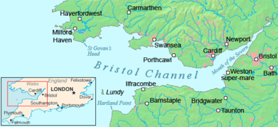
The Bristol Channel (Welsh: Môr Hafren, literal translation: "Severn Sea") is a major inlet in the island of Great Britain, separating South Wales (from Pembrokeshire to the Vale of Glamorgan) and South West England (from Devon, Somerset to North Somerset). It extends from the smaller Severn Estuary of the River Severn (Welsh: Afon Hafren) to the North Atlantic Ocean. It takes its name from the English city and port of Bristol.
Long stretches of both sides of the coastline are designated as Heritage Coast. These include Exmoor, Bideford Bay, the Hartland Point peninsula, Lundy Island, Glamorgan, Gower Peninsula, Carmarthenshire, South Pembrokeshire and Caldey Island.
Until Tudor times the Bristol Channel was known as the Severn Sea, and it is still known as this in both Welsh: Môr Hafren and Cornish: Mor Havren.[1]
- ^ The sixteenth-century geographer, Roger Barlow, defined the ‘see called severne’ as all those waters east of the Scilly Isles ‘betwene the principlitie of wales and englande’: E. G. R. Taylor (ed.), A Brief Summe of Geographie, by Roger Barlow (Abingdon, 2016), p. 32.
© MMXXIII Rich X Search. We shall prevail. All rights reserved. Rich X Search