Back Dover District CEB Ardal Dover Welsh Dover District German Dover (district) French Dover (District) FRR Dover (distretto) Italian 도버구 Korean Duvra (distrikts) Latvian/Lettish Dover (district) Dutch Dover (distrikt) NB
Dover District | |
|---|---|
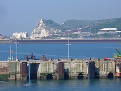
 Shakespeare Cliff and Dover town skyline and coastline | |
 Dover shown within Kent | |
| Sovereign state | United Kingdom |
| Constituent country | England |
| Region | South East England |
| Non-metropolitan county | Kent |
| Status | Non-metropolitan district |
| Admin HQ | Dover |
| Incorporated | 1 April 1974 |
| Government | |
| • Type | Non-metropolitan district council |
| • Body | Dover District Council |
| • Leadership | Leader & Cabinet |
| • MPs | Natalie Elphicke (Labour) Craig Mackinlay (Conservative) |
| Area | |
| • Total | 121.56 sq mi (314.84 km2) |
| • Rank | 116th (of 296) |
| Population (2022) | |
| • Total | 117,473 |
| • Rank | 206th (of 296) |
| • Density | 970/sq mi (370/km2) |
| Ethnicity (2021) | |
| • Ethnic groups | |
| Religion (2021) | |
| • Religion | List
|
| Time zone | UTC0 (UTC) |
| • Summer (DST) | UTC+1 (BST) |
| ONS code | 29UE (ONS) E07000108 (GSS) |
| OS grid reference | TR315415 |
Dover is a local government district in Kent, England. It is named after its largest town, the port town of Dover. The council is based in Whitfield on the outskirts of Dover. The district also covers the towns of Deal, Sandwich and Walmer as well as the surrounding rural areas.
The district borders Thanet District to the north, the City of Canterbury to the west, and Folkestone and Hythe District to the south-west. To the south and east, it faces the Strait of Dover.
- ^ a b UK Census (2021). "2021 Census Area Profile – Dover Local Authority (E07000108)". Nomis. Office for National Statistics. Retrieved 5 January 2024.
© MMXXIII Rich X Search. We shall prevail. All rights reserved. Rich X Search
