| Dry Andes | |
|---|---|
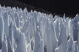
 Field of penitentes on the upper Río Blanco, Central Andes of Argentina | |
| Highest point | |
| Peak | Aconcagua |
| Elevation | 6,961 m (22,838 ft) |
| Dimensions | |
| Length | 1,200 km (750 mi) |
| Geography | |
| Country | Chile, Northwest Argentina, Bolivia |
| Parent range | Andes |

The Dry Andes (Spanish: Andes áridos) is a climatic and glaciological subregion of the Andes. Together with the Wet Andes it is one of the two subregions of the Argentine and Chilean Andes. The Dry Andes runs from the Atacama Desert in northern Chile and Northwest Argentina south to a latitude of 35°S in Chile. In Argentina the Dry Andes reaches 40°S due to the leeward effect of the Andes. According to Luis Lliboutry the Dry Andes can be defined by the distribution of penitentes.[1] The southernmost well-developed penitentes are found on Lanín Volcano.
Rock glaciers occur in parts of the Dry Andes, but are lacking in the more southern Wet Andes.[2] In the Dry Andes, ordinary glaciers develop usually at higher altitudes than rock glaciers.[2] Around Aconcagua rock glaciers reach altitudes as a low as 900 m a.s.l.[2]
The Principal Cordillera near Santiago may have been subject to significant glaciation as early as 1 million years ago, as indicated by the development of glacial valleys.[3]
- ^ "Glaciers of the Dry Andes". Louis Lliboutry, USGS. Retrieved 2008-12-21.
- ^ a b c Corte, Arturo E. (1976). "Rock glaciers". Biuletyn Peryglacjalny. 26: 175–197.
- ^ Charrier, Reynaldo; Iturrizaga, Lafasam; Charretier, Sebastién; Regard, Vincent (2019). "Geomorphologic and Glacial Evolution of the Cachapoal and southern Maipo catchments in the Andean Principal Cordillera, Central Chile (34°-35º S)". Andean Geology. 46 (2): 240–278. doi:10.5027/andgeoV46n2-3108. Retrieved June 9, 2019.
© MMXXIII Rich X Search. We shall prevail. All rights reserved. Rich X Search
