Back جغرافيا قبرص Arabic Xeografía de Xipre AST Kipr coğrafiyası Azerbaijani সাইপ্রাসের ভূগোল Bengali/Bangla Geografija Kipra BS Geografia de Xipre Catalan Γεωγραφία της Κύπρου Greek جغرافیای قبرس Persian Kyproksen maantiede Finnish Géographie de Chypre French
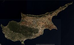
 Satellite image of Cyprus in 2022 | |
 Location of Cyprus | |
| Geography | |
| Location | Mediterranean Sea |
| Coordinates | |
| Largest city | Nicosia |
| Area | 9,251 km2 (3,572 sq mi) |
| Coastline | 648 km (402.6 mi) |
| Highest elevation | 1,952 m (6404 ft) |
| Highest point | Mount Olympus |
| Administration | |
| Capital and largest city | Nicosia |
| Area covered | 5,896 km2 (2,276 sq mi; 63.7%) |
Turkish Republic of Northern Cyprus (de facto northern administration, self-proclaimed and only recognised by Turkey) | |
| Capital and largest city | North Nicosia |
| Area covered | 3,355 km2 (1,295 sq mi; 36.3%) |
| Capital and largest settlement | Episkopi Cantonment |
| Area covered | 254 km2 (98 sq mi; 2.7%) |
| Demographics | |
| Population | 1,278,686 (2021) |
| Pop. density | 138/km2 (357/sq mi) |
| Ethnic groups | |
Cyprus is an island country in the Eastern Basin of the Mediterranean Sea. It is the third-largest island in the Mediterranean, after the Italian islands of Sicily and Sardinia, and the 80th-largest island in the world by area. It is located south of the Anatolian Peninsula, yet it belongs to the Cyprus Arc.[1] Geographically, Cyprus is located in West Asia,[2] but the country is considered a European country in political geography.[3] Cyprus also had lengthy periods of mainly Greek and intermittent Anatolian, Levantine, Byzantine, Turkish, and Western European influence.
The island is dominated by two mountain ranges, the Troodos Mountains and the Kyrenia Mountains or Pentadaktylos, and the central plain, the Mesaoria, between them.[4] The Troodos Mountains cover most of the southern and western portions of the island and account for roughly half its area.[4] The narrow Kyrenia Range extends along the northern coastline.[4] It is not as high as the Troodos Mountains, and it occupies substantially less area.[4] The two mountain ranges run generally parallel to the Taurus Mountains on the Turkish mainland, the outlines of which are visible from northern Cyprus.[4] Coastal lowlands, varying in width, surround the island.[4]
Geopolitically, the island is divided into four segments. The Republic of Cyprus, the only internationally recognized government, occupies the southern 60% of the island, and has been a member state of the European Union since 1 May 2004. The Turkish Republic of Northern Cyprus, is diplomatically recognized only by Turkey; it governs the northern one-third of the island, around 36% of the territory. The United Nations-controlled Green Line is a buffer zone that separates the two and it is about 4%. Lastly, two areas—Akrotiri and Dhekelia—remain under British sovereignty for military purposes, collectively forming the Sovereign Base Areas of Akrotiri and Dhekelia (SBA). The SBAs are located on the southern coast of the island and together encompass 254 km2, or 2.8% of the island.
- ^ "Shimon Wdowinski: Research: Eastern Mediterranean". faculty.fiu.edu.
- ^ UNSD: M49 Standard
- ^ The CIA World Factbook: Cyprus
- ^ a b c d e f Solsten, Eric, ed. (1993). Cyprus: a country study (4th ed.). Washington, D.C.: Federal Research Division, Library of Congress. pp. 50–53. ISBN 0-8444-0752-6. OCLC 27014039.
 This article incorporates text from this source, which is in the public domain.
{{cite encyclopedia}}: CS1 maint: postscript (link)
© MMXXIII Rich X Search. We shall prevail. All rights reserved. Rich X Search