Back جغرافيا السويد Arabic Xeografía de Suecia AST Геаграфія Швецыі Byelorussian География на Швеция Bulgarian সুইডেনের ভূগোল Bengali/Bangla جوگرافیای سوێد CKB Geografie Švédska Czech Daearyddiaeth Sweden Welsh Sveriges geografi Danish Γεωγραφία της Σουηδίας Greek
 | |
| Continent | Europe |
|---|---|
| Region | Scandinavia |
| Coordinates | 62°00′N 15°00′E / 62.000°N 15.000°E |
| Area | Ranked 55th |
| • Total | 450,295 km2 (173,860 sq mi) |
| • Land | 91.31% |
| • Water | 8.69% |
| Coastline | 3,218 km (2,000 mi) |
| Borders | Norway 1,666 km (1,035 mi) Finland 545 km (339 mi) Denmark 118 km (73 mi) Latvia 100 km (62 mi) Poland 100 km (62 mi) Russia (EEZ)(Kaliningrad) 15 km (9.3 mi) Lithuania 18 km (11 mi) Germany 29 km (18 mi) Estonia 30 km (19 mi) |
| Highest point | Kebnekaise 2,097 m (6,880 ft) |
| Lowest point | Kristianstad −2.41 m (−7.9 ft) |
| Longest river | Klarälven-Göta älv 720 km (450 mi) |
| Largest lake | Vänern 5,648 km2 (2,181 sq mi) |
| Climate | Temperate to subarctic |
| Terrain | Flat lowlands, mountains |
| Natural resources | Iron, copper, lead, zinc, gold, silver, tungsten, uranium, arsenic, feldspar, timber, hydropower |
| Natural hazards | Ice floe |
| Environmental issues | Acid rains, eutrophication |
| Exclusive economic zone | 160,885 km2 (62,118 sq mi) |
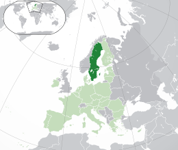
Sweden is a country in Northern Europe on the Scandinavian Peninsula. It borders Norway to the west; Finland to the northeast; and the Baltic Sea and Gulf of Bothnia to the south and east. At 450,295 km2 (173,860 sq mi), Sweden is the largest country in Northern Europe, the fifth largest in Europe, and the 55th largest country in the world.
Sweden has a 3,218 km (2,000 mi) long coastline on its east, and the Scandinavian mountain chain (Scanderna) on its western border, separating it from Norway. It has maritime borders with Denmark, Germany, Poland, Russia, Lithuania, Latvia and Estonia, and it is also linked to Denmark (southwest) by the Öresund bridge. It has an Exclusive Economic Zone of 160,885 km2 (62,118 sq mi).
© MMXXIII Rich X Search. We shall prevail. All rights reserved. Rich X Search