| Olentangy River | |
|---|---|
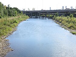
 State Route 315 passing over the Olentangy in Columbus in 2018 | |
| Physical characteristics | |
| Source | |
| • location | Approximately 2 mi (3.2 km) southeast of Galion, Ohio |
| • elevation | 1,190 ft (360 m)[1] |
| Mouth | |
• location | Scioto River at Columbus |
• elevation | 710 ft (220 m)[2] |
| Basin size | 543 sq mi (1,410 km2)[3] |
| Discharge | |
| • location | J. H. Herrick Drive, Columbus |
| • average | 789.1 cu ft/s (22.34 m3/s), USGS water years 2015-2019[4] |

The Olentangy River /oʊlənˈtændʒi/ is a 97-mile-long (156 km)[5] tributary of the Scioto River in Ohio, United States.
- ^ U.S. Geological Survey. Blooming Grove quadrangle, Ohio. 1:24,000. 7.5 Minute Series. Washington D.C.: USGS, 1988.
- ^ U.S. Geological Survey. Southwest Columbus quadrangle, Ohio. 1:24,000. 7.5 Minute Series. Washington D.C.: USGS, 1995.
- ^ "Map of Ohio watersheds". Archived from the original on 11 March 2007.
- ^ "USGS Water-Year Summary for Site 03227107". waterdata.usgs.gov. Retrieved 16 July 2020.
- ^ "The National Map". U.S. Geological Survey. Retrieved 14 February 2011.
© MMXXIII Rich X Search. We shall prevail. All rights reserved. Rich X Search
