Back جزيره سان سلفادور ARZ San Salvador adası Azerbaijani Сан-Сальвадор (востраў) Byelorussian Watling Catalan San Salvador District CEB San Salvador (Bahamy) Czech San Salvador (Bahamas) German Σαν Σαλβαντόρ (νησί) Greek Insulo San-Salvadoro Esperanto San Salvador (Bahamas) Spanish
San Salvador Island
Guanahaní Watling's Island | |
|---|---|
Island and District | |
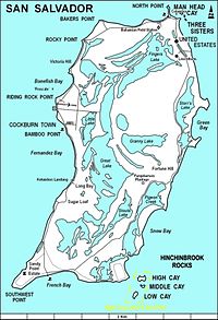
 A map of San Salvador Island | |
| Coordinates: 24°06′N 74°29′W / 24.100°N 74.483°W | |
| Country | Bahamas |
| Island | San Salvador |
| District | San Salvador |
| Area | |
| • Total | 163 km2 (63 sq mi) |
| Population (2022) | |
| • Total | 824[1] |
| Time zone | UTC−5 (Eastern Time Zone) |
| Area code | 242 |
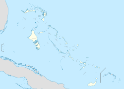
San Salvador Island, previously Watling's Island, is an island and district of the Bahamas, famed for being the probable location of Christopher Columbus's first landing of the Americas on 12 October 1492 during his first voyage. This historical importance, the island's tropical beaches, and its proximity to the United States have made tourism central to the local economy. The island has a population of 824 (2022) and is under the administration of Gilbert C. Kemp. Its largest settlement and seat of local government is Cockburn Town.
- ^ "Census Population and Housing" (PDF). Bahamas Government. Retrieved 17 April 2023.
© MMXXIII Rich X Search. We shall prevail. All rights reserved. Rich X Search
