Back Worcestershire Afrikaans Wigreċeastresċīr ANG ورشستر Arabic ورسيستيرشاير ARZ Worcestershire AST Worcestershire BAN Вустэршыр Byelorussian Ўустэршыр BE-X-OLD Устършър Bulgarian Worcestershire Breton
Worcestershire | |
|---|---|
Worcester; Broadway Tower in the Cotswolds, and the Malvern Hills on the Worcestershire–Herefordshire border | |
 Worcestershire within England | |
| Sovereign state | United Kingdom |
| Constituent country | England |
| Region | West Midlands |
| Established | 1 April 1998 |
| Established by | Local Government Commission for England |
| Preceded by | Hereford and Worcester |
| Origin | Ancient |
| Time zone | UTC±00:00 (Greenwich Mean Time) |
| • Summer (DST) | UTC+01:00 (British Summer Time) |
| Members of Parliament | |
| Ceremonial county | |
| Lord Lieutenant | Beatrice Grant[1] |
| High Sheriff | Edward Holloway[2] (2019–2020) |
| Area | 1,741 km2 (672 sq mi) |
| • Ranked | 34th of 48 |
| Population (2021) | 592,057 |
| • Ranked | 38th of 48 |
| Density | 340/km2 (880/sq mi) |
| Ethnicity |
|
| Non-metropolitan county | |
| County council | Worcestershire County Council[4] |
| Executive | Conservative |
| Admin HQ | Worcester |
| Area | 1,741 km2 (672 sq mi) |
| • Ranked | 18th of 21 |
| Population | 604,947 |
| • Ranked | 19th of 21 |
| Density | 348/km2 (900/sq mi) |
| ISO 3166-2 | GB-WOR |
| ONS code | 47 |
| GSS code | E10000034 |
| ITL | UKG12 |
| Website | worcestershire |
| Districts | |
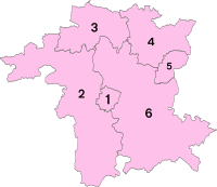
 Districts of Worcestershire | |
| Districts | |
Worcestershire (/ˈwʊstərʃər/ ⓘ WUUST-ər-shər, /-ʃɪər/ -sheer; written abbreviation: Worcs) is a ceremonial county in the West Midlands of England. It is bordered by Shropshire, Staffordshire, and the West Midlands county to the north, Warwickshire to the east, Gloucestershire to the south, and Herefordshire to the west. The city of Worcester is the largest settlement and the county town.
The county is largely rural, and has an area of 1,741 km2 (672 sq mi) and a population of 592,057. After Worcester (103,872) the largest settlements are Redditch (87,036), Kidderminster (57,400), and Malvern (30,462). It contains six local government districts, which are part of a two-tier non-metropolitan county also called Worcestershire. The county historically had complex boundaries, and included Dudley and the southwestern suburbs of Birmingham.
The River Severn flows through the centre of the county from north to south, forming a wide plain. The southwest of the county contains part of the Malvern Hills, a National Landscape which contains Worcestershire Beacon, at 425 m (1,394 ft) the county's highest point. The southwest contains a small part of the Cotswolds, and in the northwest is part of the Wyre Forest, a national nature reserve.
There is some evidence of Roman occupation in Worcestershire; the area later became part of the Anglo-Saxon kingdom of Hwicce, and then Mercia. Worcestershire was constituted as a county around 927, as the Kingdom of England formed. During the High Middle Ages the county was the site of the Battle of Evesham, in which Simon de Montfort was defeated, and in 1651 the Battle of Worcester was the last major engagement of the Wars of the Three Kingdoms. During the Industrial Revolution the north of the county was part of the Black Country, a major manufacturing centre, Kidderminster became famous for carpet production, and Worcester for porcelain.
- ^ Number 10 website Accessed 2-3-2024.
- ^ "Privy Council Office-APPOINTMENT OF SHERIFFS". London Gazette. Retrieved 17 April 2019.
- ^ "Census 2011:KS201EW Ethnic group, local authorities in England and Wales". ons.gov.uk. Office of National Statistics. Retrieved 9 December 2019.
- ^ Worcestershire County Council. "Worcestershire County Council". Archived from the original on 21 November 2008.
© MMXXIII Rich X Search. We shall prevail. All rights reserved. Rich X Search


