Back Zugspitze Afrikaans Zugspitze AN قمة تسوغشبيتسه Arabic جبل قمه تسوجشبيتسه ARZ Zugspitz BAR Цугшпіцэ Byelorussian Цугшпіцэ BE-X-OLD Цугшпице Bulgarian Zugspitze Breton Zugspitze BS
| Zugspitze | |
|---|---|
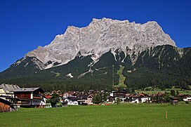
 Zugspitze from Ehrwald, Tyrol, Austria | |
| Highest point | |
| Elevation | 2,962 m (9,718 ft)[1] |
| Prominence | 1,746 m (5,728 ft)[2] ↓ Fern Pass → Parseierspitze |
| Parent peak | Finsteraarhorna / Mont Blancb |
| Isolation | 25.8 km → Zwölferkogel[Note 1] |
| Listing | Country high point (Germany) Ultra |
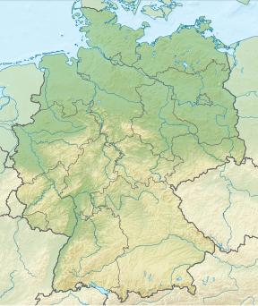
| Coordinates | 47°25′16″N 10°59′07″E / 47.42111°N 10.98528°E[2] |
| Geography | |
| Location | Tyrol, Austria Bavaria, Germany |
| Parent range | Wettersteingebirge, Eastern Alps |
| Geology | |
| Age of rock | Triassic |
| Mountain type | Wetterstein limestone[3] |
| Climbing | |
| First ascent | 27 August 1820 by Josef Naus, Johann Georg Tauschl and survey assistant, Maier |
| Easiest route | Reintal Route |
The Zugspitze (/ˈzʊɡʃpɪtsə/ ZUUG-shpit-sə,[4] German: [ˈtsuːkˌʃpɪtsə] ; lit. '[avalanche] path peak'), at 2,962 m (9,718 ft) above sea level, is the highest peak of the Wetterstein Mountains and the highest mountain in Germany. It lies south of the town of Garmisch-Partenkirchen in Bavaria, and the Austria–Germany border is on its western summit. South of the mountain is the Zugspitzplatt, a high karst plateau with numerous caves. On the flanks of the Zugspitze are two glaciers, the largest in Germany: the Northern Schneeferner with an area of 30.7 hectares and Höllentalferner with an area of 24.7 hectares. Shrinking of the Southern Schneeferner led to the loss of glacier status in 2022.[5]
The Zugspitze was first climbed on 27 August 1820 by Josef Naus; his survey assistant, Maier, and mountain guide, Johann Georg Tauschl. Today there are three normal routes to the summit: one from the Höllental valley to the northeast; another out of the Reintal valley to the southeast; and the third from the west over the Austrian Cirque (Österreichische Schneekar). One of the best known ridge routes in the Eastern Alps runs along the knife-edged Jubilee Ridge (Jubiläumsgrat) to the summit, linking the Zugspitze, the Hochblassen and the Alpspitze. For mountaineers there is plenty of nearby accommodation. On the western summit of the Zugspitze itself is the Münchner Haus and on the western slopes is the Wiener-Neustädter Hut.
Three cable cars run to the top of the Zugspitze. The first, the Tyrolean Zugspitze Cable Car, was built in 1926 by the German company Adolf Bleichert & Co[6] and terminated on an arête below the summit at 2,805 m.a.s.l, the so-called Kammstation, before the terminus was moved to the actual summit at 2,951 m.a.s.l. in 1991. A rack railway, the Bavarian Zugspitze Railway, runs inside the northern flank of the mountain and ends on the Zugspitzplatt, from where a second cable car runs a short way down to the Schneefernerhaus, formerly a hotel, but since 1999 an environmental research station; a weather station opened there in 1900. The rack railway and the Eibsee Cable Car, the third cableway, transport an average of 500,000 people to the summit each year. In winter, nine ski lifts cover the ski area on the Zugspitzplatt.
- ^ "Zugspitze : Climbing, Hiking & Mountaineering". SummitPost. Retrieved 22 April 2013.
- ^ a b Aaron Maizlish. "Europe Ultra-Prominences". peaklist.org. Retrieved 22 April 2013.
- ^ Geologische Karte von Bayern mit Erläuterungen (1:500,000). Bavarian Geological Survey, 1998.
- ^ Wells, John C. (2008). Longman Pronunciation Dictionary (3rd ed.). Longman. ISBN 978-1-4058-8118-0.
- ^ "Germany's Southern Schneeferner loses glacier status | Copernicus". Copernicus. European Union, Copernicus Sentinel-2 imagery. 30 September 2022. Retrieved 5 March 2023.
- ^ Peter von Bleichert "Bleichert's Wire Ropeways"
Cite error: There are <ref group=Note> tags on this page, but the references will not show without a {{reflist|group=Note}} template (see the help page).
© MMXXIII Rich X Search. We shall prevail. All rights reserved. Rich X Search

