Back Andaman- en Nicobar-eilande Afrikaans अंडमान आरू निकोबार द्वीपसमूह ANP جزر أندمان ونيكوبار Arabic আন্দামান আৰু নিকোবৰ দ্বীপপুঞ্জ Assamese Islles Andamán y Nicobar AST अंडमान अउर निकोबार द्वीपसमूह AWA Andaman və Nikobar adaları Azerbaijani آندامان و نیکوبار آدالاری AZB Kapuloan Andaman miwah Nikobar BAN Андаманскія і Нікабарскія астравы Byelorussian
Andaman and Nicobar Islands | |
|---|---|
|
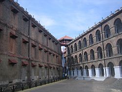
Clockwise from top-right: Coral reefs around the islands; Beach at Shaheed Dweep; Andaman Sea; Cellular Jail in Port Blair; Aerial view of Nicobar Islands; Havelock Island | |
| Motto(s): Satyameva Jayate (Truth alone triumphs) | |
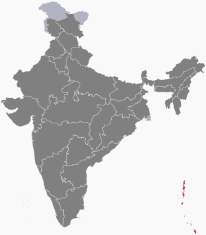
 Location of Andaman and Nicobar Islands in India | |
| Coordinates: 11°41′N 92°43′E / 11.68°N 92.72°E | |
| Country | |
| Region | East India |
| Formation | 1 November 1956 |
| Capital and largest city | Port Blair |
| Districts | 3 |
| Government | |
| • Body | Government of Andaman and Nicobar Islands |
| • Lieutenant governor | Devendra Kumar Joshi |
| • Chief secretary | Keshav Chandra, IAS |
| National Parliament | Parliament of India |
| • Lok Sabha | 1 seat |
| High Court | Calcutta High Court (Port Blair Bench) |
| Area | |
| • Total | 8,249 km2 (3,185 sq mi) |
| • Rank | 29th |
| Dimensions | |
| • Length | 467 km (290 mi) |
| • Width | 24 km (15 mi) |
| Elevation | 568 m (1,864 ft) |
| Highest elevation | 737 m (2,418 ft) |
| Lowest elevation | 0 m (0 ft) |
| Population (2011)[2] | |
| • Total | 380,581 |
| • Rank | 34th |
| • Density | 46/km2 (120/sq mi) |
| • Urban | 37.7% |
| • Rural | 62.3% |
| Demonym(s) | Andamanese, Nicobarese |
| Language | |
| • Official | |
| • Official script | |
| GDP | |
| • Total (2021-22) | |
| • Rank | 33rd |
| Time zone | UTC+05:30 (IST) |
| ISO 3166 code | IN-AN |
| Vehicle registration | AN |
| HDI (2019) | |
| Literacy (2017) | 86.27 (12th) |
| Sex ratio (2011) | 876♀/1000 ♂ (22nd) |
| Website | andaman |
| Symbols of Andaman and Nicobar Islands | |
 | |
| Bird | Andaman wood pigeon |
| Flower | Pyinma |
| Mammal | Dugong |
| Tree | Andaman Padauk |
| List of Indian state and union territory symbols | |
The Andaman and Nicobar Islands is a union territory of India. It consists of 836 islands (of which only 31 are inhabited) grouped into two island groups: the northern Andaman Islands and the southern Nicobar Islands, separated by a 150 km (93 mi) wide channel. Port Blair is the capital and largest city of the territory, located about 1,190 km (740 mi) from Chennai and 1,255 km (780 mi) from Kolkata in mainland India. The islands are sandwiched between the Bay of Bengal to the west and the Andaman Sea to the east with the northern-most point located 901 km (560 mi) from the mouth of Hooghly river. Indira Point at 6°45’10″N and 93°49’36″E at the southern tip of Great Nicobar is the southernmost point of India.
The territory shares maritime borders with Indonesia located about 165 km (103 mi) to the south, Myanmar located 280 km (170 mi) to the north-east and Thailand located 650 km (400 mi) to the south-east. The islands occupy a total land area of approximately 8,249 km2 (3,185 sq mi) with a population of 380,581 as per the 2011 census. The territory is divided into three districts: Nicobar, South Andaman, and North and Middle Andaman with the capitals at Car Nicobar, Port Blair and Mayabunder respectively.
Genetic and cultural studies suggest that the indigenous Andamanese people may have been isolated from other populations during the Middle Paleolithic era, more than 30,000 years ago. Archeological evidence of civilization has been dated back to 2,200 years. In the 11th century CE, Cholas, one of the three Tamil kingdoms, used the islands as a naval base to launch expeditions in South East Asia. The Danish were the first Europeans to arrive on the islands in 1755. The islands became part of the British Raj in 1868. During the Second World War, the islands were invaded by the Japanese Empire. After Indian Independence in 1947, the region became a province and later a union territory after the adoption of the Constitution of India in 1950.
The islands host the Andaman and Nicobar Command, the only geographical command operated jointly by the three major wings of the Indian Armed Forces: the Army, the Air Force and the Navy. While Hindi and English are the official languages, the major spoken languages include Bengali, Tamil and Telugu. Indigenous people speak any of the Andamanese or Nicobarese family of languages. Hinduism is the majority religion in the union territory, with a significant Christian minority. The islands are also home to the Sentinelese people, an uncontacted tribe.
- ^ Socio-economic statistics (PDF) (Report). Government of India. Retrieved 1 January 2019.
- ^ State-wise population (Report). Government of India. Retrieved 1 January 2024.
© MMXXIII Rich X Search. We shall prevail. All rights reserved. Rich X Search


