Back Бастонь Byelorussian Бастон Bulgarian Bastogne Breton Bastogne Catalan Bastogne (parokya) CEB Bastogne Czech Bastogne Danish Bastogne German Μπαστόν Greek Bastogne Esperanto
Bastogne
| |
|---|---|
City and municipality | |
 | |
| Coordinates: 50°0.25′N 05°43.2′E / 50.00417°N 5.7200°E | |
| Country | |
| Community | French Community |
| Region | Wallonia |
| Province | Luxembourg |
| Arrondissement | Bastogne |
| Government | |
| • Mayor | Benoît Lutgen (cdH) |
| • Governing party/ies | LDB-cdH |
| Area | |
| • Total | 173.03 km2 (66.81 sq mi) |
| Population (2018-01-01)[1] | |
| • Total | 15,894 |
| • Density | 92/km2 (240/sq mi) |
| Postal codes | 6600 |
| NIS code | 82003 |
| Area codes | 061 |
| Website | www.bastogne.be |
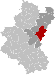
Bastogne (French pronunciation: [bas.tɔɲ] ; Dutch: Bastenaken [ˈbɑstəˌnaːkə(n)] ; German: Bastnach/Bastenach [ˈbast(ə)nax]; Luxembourgish: Baaschtnech [ˈbaːʃtnəɕ] ) is a city and municipality of Wallonia located in the province of Luxembourg in the Ardennes, Belgium.
The municipality consists of the following districts: Bastogne, Longvilly, Noville, Villers-la-Bonne-Eau, and Wardin. The town is situated on a ridge in the Ardennes at an elevation of 510 metres (1,670 ft).
On 1 January 2025, it will merge with Bertogne into a new municipality.
- ^ "Wettelijke Bevolking per gemeente op 1 januari 2018". Statbel. Retrieved 9 March 2019.
© MMXXIII Rich X Search. We shall prevail. All rights reserved. Rich X Search


