Back Phan Rang Air Base CEB پایگاه هوایی فان رنگ Persian Пойгоҳи ҳавоии Пҳан Ранг Tajik Sân bay Thành Sơn Vietnamese
| Phan Rang Air Base | |
|---|---|
| Part of Vietnam People's Air Force (VPAF) Republic of Vietnam Air Force (RVNAF) Pacific Air Forces (USAF) | |
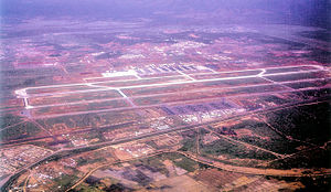
 Phan Rang Air Base, South Vietnam 1967 | |
| Coordinates | 11°38′06″N 108°57′01″E / 11.63500°N 108.95028°E |
| Type | Air Force Base |
| Site information | |
| Controlled by | |
| Condition | Seized 1975 by PAVN, in use as military airfield |
| Site history | |
| Built | 1942 (rebuilt 1965) |
| In use | 1942–1954; 1965–present |
| Battles/wars | Vietnam War |
| Garrison information | |
| Garrison | 937th Fighter Regiment (VPAF) 92d Tactical Wing (RVNAF) 366th Tactical Fighter Wing (USAF) 35th Tactical Fighter Wing (USAF) 315th Tactical Airlift Wing (USAF) 14th Special Operations Wing (USAF) |
Airfield information | |||||||||||||||||||
|---|---|---|---|---|---|---|---|---|---|---|---|---|---|---|---|---|---|---|---|
| Summary | |||||||||||||||||||
| Elevation AMSL | 32 m / 105 ft | ||||||||||||||||||
| Coordinates | 11°38′01″N 108°57′07″E / 11.63361°N 108.95194°E | ||||||||||||||||||
| Runways | |||||||||||||||||||
| |||||||||||||||||||
Phan Rang Air Base (also called Thành Sơn Air Base) is a Vietnam People's Air Force (VPAF) (Khong Quan Nhan Dan Viet Nam) military airfield in Vietnam. It is located 5.2 miles (4.5 nmi; 8.4 km) north-northwest of Phan Rang – Tháp Chàm in Ninh Thuận Province.
Initially built by the Imperial Japanese Army about 1942, the airfield was also used by the French Air Force (French: Armée de l'Air) during the First Indochina War then abandoned in 1954. The United States rebuilt the airfield in 1965 and it was used by the Republic of Vietnam Air Force (RVNAF) and the United States Air Force during the Vietnam War in the II Corps Tactical Zone of South Vietnam.
It was seized by the People's Army of Vietnam (PAVN) in April 1975 and has been in use by the VPAF ever since.
© MMXXIII Rich X Search. We shall prevail. All rights reserved. Rich X Search


