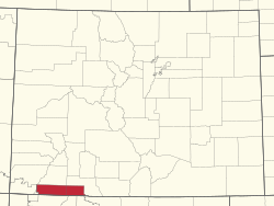
Southern Ute Indian Reservation | |
|---|---|
 Location in Colorado | |
| Coordinates: 37°06′30″N 107°38′42″W / 37.10833°N 107.64500°W | |
| Tribe | Southern Ute |
| Country | United States |
| State | Colorado |
| Counties | La Plata Archuleta Montezuma Counties |
| Headquarters | Ignacio |
| Government | |
| • Body | Tribal Council |
| • Chairman | Melvin J. Baker |
| • Vice-Chairman | Lorelei Cloud |
| • Treasurer | Marvin Pinnecoose |
| Population (2020)[2] | |
| • Total | 12,321 |
| Website | southernute-nsn.gov |
The Southern Ute Indian Reservation (Ute dialect: Kapuuta-wa Moghwachi Núuchi-u) is an Indian reservation in southwestern Colorado, United States, near the northern New Mexico state line. Its territory consists of land from three counties; in descending order of surface area they are La Plata, Archuleta, and Montezuma Counties. The reservation has a land area of 1,058.785 sq mi (2,742.24 km²). Its largest communities are Ignacio and Arboles.[3] The only other community that is recognized as a separate place by the Census Bureau is the CDP of Southern Ute, which lies just southeast of Ignacio.
- ^ "Southern Ute Tribal Council". Retrieved July 24, 2019.
- ^ 2013-2017 American Community Survey 5-Year Estimates. "My Tribal Area". United States Census Bureau.
{{cite web}}: CS1 maint: numeric names: authors list (link) - ^ Southern Ute Reservation, Colorado Archived 2020-02-11 at archive.today United States Census Bureau.
© MMXXIII Rich X Search. We shall prevail. All rights reserved. Rich X Search

