Back Charing Cross Afrikaans تشارينغ كروس Arabic چرینق کراس AZB Чарынг-Крос Byelorussian Charing Cross Catalan Charing Cross Czech Charing Cross Welsh Charing Cross Danish Charing Cross German Charing Cross Esperanto
| Charing Cross | |
|---|---|
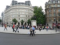
 Charing Cross roundabout, with a Statue of Charles I on the site of the original Eleanor Cross in the then hamlet of Charing, an important junction since the middle ages. | |
Location within Greater London | |
| OS grid reference | TQ302804 |
| London borough | |
| Ceremonial county | Greater London |
| Region | |
| Country | England |
| Sovereign state | United Kingdom |
| Post town | LONDON |
| Postcode district | WC2 |
| Dialling code | 020 |
| Police | Metropolitan |
| Fire | London |
| Ambulance | London |
| UK Parliament | |
| London Assembly | |
Charing Cross (pronounced /ˈtʃærɪŋ/ CHA-ring)[1] is a junction in Westminster, London, England, where six routes meet. Since the early 19th century, Charing Cross has been the notional "centre of London" and became the point from which distances from London are measured. Clockwise from north, the routes that meet at Charing Cross are the east side of Trafalgar Square leading to St Martin's Place and then Charing Cross Road; the Strand leading to the City; Northumberland Avenue leading to the Thames Embankment; Whitehall leading to Parliament Square; The Mall leading to Admiralty Arch and Buckingham Palace; and two short roads leading to Pall Mall.
Historically, the name was derived from the hamlet of Charing ('Riverbend') that occupied the area of this important road junction in the middle ages, together with the grand Eleanor Cross that once marked the site. The medieval monumental cross, the Charing Cross (1294–1647), was the largest and most ornate instance of a chain of medieval Eleanor crosses running from Lincoln to this location. It was a landmark for many centuries of the hamlet of Charing, Westminster, which later gave way to government property; a little of The Strand; and Trafalgar Square. The cross in its various historical forms has also lent its name to its locality, including Charing Cross Station. On the forecourt of this terminus station stands the ornate Queen Eleanor Memorial Cross, a taller emulation of the original, and built to mark the station's opening in 1864.
A bronze equestrian statue of Charles I, erected in 1675, stands on a high plinth, situated roughly where the medieval monumental cross (the 'Charing Cross') had previously stood for 353 years (since its construction in 1294) until destroyed in 1647 by the revolutionary government of Oliver Cromwell. The famously beheaded King, appearing ascendant, is the work of French sculptor Hubert Le Sueur. Charing Cross is marked on contemporary maps as the road junction around the statue's traffic island, though it is also a thoroughfare in postal addresses: Drummonds Bank, on the corner with The Mall, retains the address 49 Charing Cross and 1-4 Charing Cross continues to exist.[2][3] The name previously applied to the whole stretch of road between Great Scotland Yard and Trafalgar Square, but since 1 January 1931 most of this section of road has been designated part of the 'Whitehall' thoroughfare.[4]
- ^ "Charing Cross" entry in Collins English Dictionary.
- ^ Charing Cross Express Tesco
- ^ Flickr. Charing Cross (note also "Charing Cross" street sign, upper left)
- ^ Local attractions – Charing Cross Archived 26 March 2012 at the Wayback Machine, londoncountyhall.com
© MMXXIII Rich X Search. We shall prevail. All rights reserved. Rich X Search
