Back Fosse Way Catalan Fosse Way Czech Ffordd y Ffosydd Welsh Fosse Way German Fosse Way Spanish Fosse Way Finnish Fosse Way French Fosse Way Italian Fosse Way Latin Fosse Way Dutch
| Fosse Way | |
|---|---|
| Roman Road | |
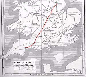
 The route of the Fosse Way | |
| Route information | |
| Length | 230 mi (370 km) |
| Time period | Roman Britain |
| Margary number | 5 |
| Major junctions | |
| From | Isca Dumnoniorum |
| Lindinis, Aquae Sulis, Corinium, Venonis, Ratae Corieltauvorum | |
| To | Lindum Colonia |
| Location | |
| Country | United Kingdom |
| Road network | |

The Fosse Way was a Roman road built in Britain during the first and second centuries AD that linked Isca Dumnoniorum (Exeter) in the southwest and Lindum Colonia (Lincoln) to the northeast, via Lindinis (Ilchester), Aquae Sulis (Bath), Corinium (Cirencester), and Ratae Corieltauvorum (Leicester).
© MMXXIII Rich X Search. We shall prevail. All rights reserved. Rich X Search