Back Leith Hill (bungtod sa Hiniusang Gingharian) CEB Leith Hill German Leith Hill Latin Leith Hill NN Leith Hill NB Leith Hill Swedish
| Leith Hill | |
|---|---|
 | |
| Highest point | |
| Elevation | 294 m (965 ft) |
| Prominence | 249 m (817 ft) |
| Listing | Marilyn,[1] Hardy, County Top |
| Coordinates | 51°10′33″N 0°22′11″W / 51.17583°N 0.36972°W |
| Geography | |
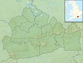
Leith Hill in Surrey | |
| Location | Surrey, England |
| Parent range | Greensand Ridge |
| OS grid | TQ139431 |
| Topo map | OS Landranger 187 |
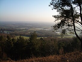
Leith Hill in southern England is the highest summit of the Greensand Ridge,[2] approximately 6.7 km (4 mi) southwest of Dorking, Surrey and 40.5 km (30 mi) southwest of central London. It reaches 294 m (965 ft) above sea level,[3] and is the second highest point in southeast England, after Walbury Hill in southwest Berkshire, (which is 297 m (974 ft) high).[1] Leith Hill is the highest ground for 79 km (49 mi).
Four areas of woodland surrounding the hill comprise the 337.9-hectare (835-acre) Leith Hill Site of Special Scientific Interest, although the summit is excluded from this designation.[4]
The nearest railway station is Holmwood station, 3.6 km (2 mi) to the east, served by Southern trains to London Victoria.[5]
- ^ a b Dawson, Alan (1992). "The Marilyns by Height". The Relative Hills of Britain. Milnthorpe, Cumbria, England: Cicerone Press. ISBN 1-85284-068-4. Archived from the original on 22 August 2010. Dawson draws his information from various editions of Ordnance Survey maps, but he does not specify which.
- ^ Gallois, RW; Edmunds, MA (1965). The Wealden District. British Geological Survey. ISBN 0-11-884078-9.
- ^ Bench marks km square TQ1343 Archived 25 July 2011 at the Wayback Machine: The exact height of the benchmark on the tower, surveyed in 1972, is 293.8730 metres AMSL. The cut mark is 0.5 m off the ground, hence a height of 293.4 m. On the 1:50000 ordnance map this is rounded to 294 m. Dorking, Reigate and Crawley area (Map) (10GSGS ed.). 1:50000. Landranger 187. Ordnance Survey. 1991. ISBN 0-319-22187-3.
- ^ "Designated Sites View: Leith Hill". Sites of Special Scientific Interest. Natural England. Archived from the original on 9 November 2018. Retrieved 9 November 2018.
- ^ Bathurst, David (2012). Walking the county high points of England. Chichester: Summersdale. pp. 132–137. ISBN 978-1-84-953239-6.
© MMXXIII Rich X Search. We shall prevail. All rights reserved. Rich X Search
