Back روبرتس لاند Arabic Rupertin torpağı Azerbaijani Зямля Руперта Byelorussian Terra de Rupert Catalan Země prince Ruprechta Czech Rupert's Land Danish Ruperts Land German Γη του Ρούπερτ Greek Rupertlando Esperanto Tierra de Rupert Spanish
| Prince Rupert's Land | |||||||
|---|---|---|---|---|---|---|---|
| Territory of British North America | |||||||
| 1670–1870 | |||||||
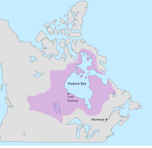
 Map of Rupert's Land, showing the location of York Factory | |||||||
| Government | |||||||
| • Type | Trading company | ||||||
| Monarch | |||||||
• 1670–1685 (first) | Charles II | ||||||
• 1837–1870 (last) | Victoria | ||||||
| HBC Governor | |||||||
• 1670–1682 (first) | Rupert of the Rhine | ||||||
• 1870 (last) | Stafford Northcote | ||||||
| Historical era | Age of Discovery | ||||||
• Established | 1670 | ||||||
• Disestablished | 15 July 1870 | ||||||
| |||||||
| Today part of | Canada ∟ Alberta ∟ Manitoba ∟ Northwest Territories ∟ Nunavut ∟ Ontario ∟ Quebec ∟ Saskatchewan United States ∟ Minnesota ∟ North Dakota ∟ South Dakota ∟ Montana | ||||||
Rupert's Land (French: Terre de Rupert), or Prince Rupert's Land (French: Terre du Prince Rupert), was a territory in British North America which comprised the Hudson Bay drainage basin. The right to "sole trade and commerce" over Rupert's Land was granted to the Hudson's Bay Company (HBC), based at York Factory, effectively giving that company a commercial monopoly over the area. The territory operated for 200 years from 1670 to 1870. Its namesake was Prince Rupert of the Rhine, who was a nephew of King Charles I and the first governor of HBC. In December 1821, the HBC monopoly was extended from Rupert's Land to the Pacific coast.
The areas formerly belonging to Rupert's Land lie mostly within what is today Canada, and included the whole of Manitoba, most of Saskatchewan, southern Alberta, southern Nunavut, and northern parts of Ontario and Quebec. Additionally, it also extended into areas that would eventually become part of Minnesota, North Dakota, and Montana. The southern border west of Lake of the Woods to the Rocky Mountains was the drainage divide between the Mississippi and Red/Saskatchewan watersheds until the Anglo-American Convention of 1818 substituted the 49th parallel.
© MMXXIII Rich X Search. We shall prevail. All rights reserved. Rich X Search
