Back پرستون AZB Preston District CEB Dinas Preston Welsh City of Preston German پرستون Persian Cité de Preston (Lancashire) French City of Preston FRR シティ・オブ・プレストン Japanese 시티오브프레스턴 Korean City of Preston Kurdish
City of Preston | |
|---|---|
| Preston | |
 | |
| Motto: Prince of Peace (Princeps Pacis) | |
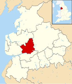
 Shown within Lancashire and England | |
| Coordinates: 53°45′N 2°42′W / 53.750°N 2.700°W | |
| Country | United Kingdom |
| Country | England |
| Region | North West England |
| County | Lancashire |
| Guild Merchant charter | 1179 |
| City status | 2002 |
| Government | |
| • Type | Non-metropolitan district |
| • Local Authority | Preston City Council |
| • Leadership: | Leader & Cabinet |
| • MPs: | Mark Hendrick (Lab), Ben Wallace (Con), Mark Menzies (Con) |
| Area | |
| • City & Non-metropolitan district | 55 sq mi (142 km2) |
| Highest elevation | 873 ft (266 m) |
| Lowest elevation | 0 ft (0 m) |
| Population (2022) | |
| • City & Non-metropolitan district | 151,582 (Ranked 144th) |
| • Density | 2,760/sq mi (1,065/km2) |
| • Urban | 365,000 (Central Lancashire) |
| Ethnicity (2021) | |
| • Ethnic groups | |
| Religion (2021) | |
| • Religion | List
|
| Time zone | UTC+0 (Greenwich Mean Time) |
| Postcode | |
| Area code(s) | 01772, 01995 |
| ISO 3166-2 | GB-LAN |
| ONS code | 30UK (ONS) E07000123 (GSS) |
| OS grid reference | SD535295 |
| Demonym | Prestonian |
The City of Preston, or simply Preston (/ˈprɛstən/ ),[2] is a local government district with city status in Lancashire, England. It lies on the north bank of the River Ribble and has a population of 151,582 (2022).[3][4] The neighbouring districts are Ribble Valley, South Ribble, Fylde and Wyre.
The district is named after its largest settlement, Preston, which lies in the south of the district. The district also includes rural areas to the north of the main urban area, including part of the Forest of Bowland, a designated Area of Outstanding Natural Beauty. In 2002 the district was granted city status to mark the Golden Jubilee of Elizabeth II; prior to this it was known as the Borough of Preston, having held borough status since its creation in 1974.[5][6]
- ^ a b UK Census (2021). "2021 Census Area Profile – Preston Local Authority (E07000123)". Nomis. Office for National Statistics. Retrieved 5 January 2024.
- ^ "Local Authority Districts, Counties and Unitary Authorities (April 2021) Map in United Kingdom". Office for National Statistics: Open Geography Portal. Retrieved 1 August 2023.
- ^ "Labour Market Profile - Nomis - Official Census and Labour Market Statistics". www.nomisweb.co.uk. Retrieved 18 May 2023.
- ^ "Mid-Year Population Estimates, UK, June 2022". Office for National Statistics. 26 March 2024. Retrieved 3 May 2024.
- ^ "District Councils and Boroughs". Parliamentary Debates (Hansard). 28 March 1974. Retrieved 16 January 2012.
- ^ "Table III(a)". Local Government in England and wales. a Guide to the New System. London: HMSO. 1974. pp. 15–109. ISBN 0117508470.
© MMXXIII Rich X Search. We shall prevail. All rights reserved. Rich X Search

