Back Homonhon CEB Homonhon German هومونهون Persian Homonhon ILO Homonhon Italian ホモンホン島 Japanese 호몬혼섬 Korean Homonhona Latvian/Lettish Хомонхон MRJ Homonhon Dutch
Nickname: Magellan's First Landing Site | |
|---|---|
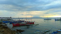
 Homonhon Island, Guiuan, Eastern Samar at sunset (view southwest from Guiuan Integrated Transport Terminal) | |
| Geography | |
| Coordinates | 10°45′20″N 125°44′21″E / 10.75556°N 125.73917°E |
| Adjacent to | |
| Area | 105.2 km2 (40.6 sq mi)[1] |
| Coastline | 57.5 km (35.73 mi)[1] |
| Highest elevation | 1,227 ft (374 m)[1] |
| Highest point | Homonhon Peak |
| Administration | |
| Region | Eastern Visayas |
| Province | Eastern Samar |
| Municipality | Guiuan |
| Largest settlement | Casuguran (pop. 1,032) |
| Demographics | |
| Population | 4,722 (2024) |
| Pop. density | 41.9/km2 (108.5/sq mi) |
Homonhon Island is an island in the province of Eastern Samar, Philippines, on the east side of Leyte Gulf. The 20-kilometre (12 mi) long island is part of the municipality of Guiuan, encompassing eight barangays: Bitaugan, Cagusu-an, Canawayon, Casuguran, Culasi, Habag, Inapulangan, and Pagbabangnan.
Mantoconan, an islet just off the northwest corner of Homonhon, is also part of the approximately 7,500 islands comprising the Philippine Archipelago. The island is one of the early Pacific contact sites between the East and the West.
- ^ a b c "Islands of Philippines". Island Directory. United Nations Environment Programme. Retrieved 3 October 2017.
© MMXXIII Rich X Search. We shall prevail. All rights reserved. Rich X Search
