Back Or bərzəxi Azerbaijani Перакопскі перашыек Byelorussian Перакопскі пярэсмык BE-X-OLD Перекопски провлак Bulgarian Istme de Perekop Catalan Perekopskiy Peresheyek CEB Or boynu CRH Perekopská šíje Czech Перекоп пымакĕ CV Landenge von Perekop German

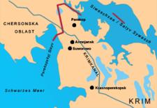
The Isthmus of Perekop, literally Isthmus of the Trench (Ukrainian: Перекопський перешийок; transliteration: Perekops'kyi pereshyiok; Russian: Перекопский перешеек; transliteration: Perekopskiy peresheek, Crimean Tatar: Or boynu, Turkish: Orkapı; Greek: Τάφρος; transliteration: Taphros), is the narrow, 5–7 kilometres (3.1–4.3 mi) wide strip of land that connects the Crimean Peninsula to the mainland of Ukraine. The isthmus projects between the Black Sea to the west and the Syvash to the east. The isthmus takes its name of "Perekop" from the Tatar fortress of Or Qapi.
The border between Ukraine's Autonomous Republic of Crimea and Kherson Oblast runs through the northern part of the isthmus. Since the Russian military annexation of Crimea in 2014, this is also the de facto northern border of the Russian Republic of Crimea. The cities of Perekop, Armiansk, Suvorove (Crimea) and Krasnoperekopsk are situated on the isthmus. The North Crimean Canal ran through the isthmus, supplying Crimea with fresh water from the Dnieper River. Ukraine closed the canal in 2014, and the water supply was only partially replaced by other local and Russian sources.
Rich salt ores are located in the south of the isthmus and are of commercial importance to the region.
© MMXXIII Rich X Search. We shall prevail. All rights reserved. Rich X Search