Back نانتيكوك Arabic نانتیکوک، پنسیلوانیا AZB Нантикок (Пенсильвани) CE Nanticoke (lungsod sa Tinipong Bansa, Pennsylvania) CEB Nanticoke, Pennsylvania Welsh Nanticoke DAG Nanticoke (Pennsylvania) German Nanticoke Esperanto Nanticoke (Pensilvania) Spanish Nanticoke (Pennsylvania) Basque
Nanticoke, Pennsylvania | |
|---|---|
 Aerial view of Nanticoke | |
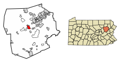
 Location of Nanticoke in Luzerne County, Pennsylvania | |
Location of Nanticoke in Pennsylvania | |
| Coordinates: 41°11′58″N 75°59′57″W / 41.19944°N 75.99917°W | |
| Country | United States |
| State | Pennsylvania |
| County | Luzerne |
| Settled | 1800 |
| Incorporated (borough) | 1874 |
| Incorporated (city) | 1926 |
| Government | |
| • Type | City Council |
| • Mayor | Kevin Coughlin |
| Area | |
| • Total | 3.55 sq mi (9.20 km2) |
| • Land | 3.46 sq mi (8.95 km2) |
| • Water | 0.09 sq mi (0.25 km2) |
| Elevation | 696 ft (212 m) |
| Population | |
| • Total | 10,628 |
| • Density | 3,074.34/sq mi (1,186.90/km2) |
| Time zone | UTC-5 (Eastern (EST)) |
| • Summer (DST) | UTC-4 (EDT) |
| Zip Code | 18634 |
| Area code | 570 |
| FIPS code | 42-52584 |
| Website | nanticokecity.com |
Nanticoke is a city in Luzerne County, Pennsylvania, United States. As of the 2020 census, the population was 10,628, making it the third largest city in Luzerne County. It occupies 3.6 square miles (9.3 km2) of land. Nanticoke is part of Northeastern Pennsylvania.
The city can be divided into several sections: Honey Pot (northwestern Nanticoke), (northern and central Nanticoke), and Hanover Section (southeastern Nanticoke).[3] It was once an active coal mining community. Today, the 167-acre main campus of Luzerne County Community College is located within the city.
- ^ "ArcGIS REST Services Directory". United States Census Bureau. Retrieved October 12, 2022.
- ^ Cite error: The named reference
USCensusDecennial2020CenPopScriptOnlywas invoked but never defined (see the help page). - ^ "Honey Pot". nanticokehistoryonline.org. Archived from the original on August 6, 2017. Retrieved September 8, 2017.
© MMXXIII Rich X Search. We shall prevail. All rights reserved. Rich X Search


