Back هايوارد (كاليفورنيا) Arabic هايوارد (كاليفورنيا) ARZ Heyvard (Kaliforniya) Azerbaijani هایوارد، کالیفورنیا AZB Хейвард (Каліфорнія) Byelorussian Хейуърд Bulgarian Hayward (Califòrnia) Catalan Гейвард (Калифорни) CE Hayward (lungsod sa Tinipong Bansa, California) CEB Hayward DAG
Hayward | |
|---|---|
|
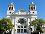
Top: Holy Sepulcher Church; Portuguese Memorial Park; Hayward Water Tower. Bottom: City Hall; All Saints Church. | |
| Nickname: Haystack | |
| Motto: Heart of the Bay[1] | |
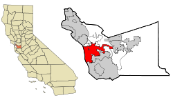
 Location of Hayward in Alameda County, California | |
| Coordinates: 37°40′08″N 122°04′51″W / 37.668820°N 122.080796°W[2] | |
| Country | United States |
| State | California |
| County | Alameda |
| Incorporated | March 11, 1876[3] |
| Government | |
| • Type | Council-Manager |
| • Mayor | Mark Salinas[4] |
| • State Senate | Aisha Wahab (D)[5] |
| • Assemblymember | Liz Ortega (D)[6] |
| • U. S. rep. | Eric Swalwell (D)[7] |
| Area | |
| • City | 64.06 sq mi (165.92 km2) |
| • Land | 45.77 sq mi (118.56 km2) |
| • Water | 18.29 sq mi (47.36 km2) 28.9% |
| Elevation | 105 ft (32 m) |
| Population | |
| • City | 162,954 |
| • Rank | 3rd in Alameda County 34th in California 164th in the United States |
| • Density | 2,500/sq mi (980/km2) |
| Time zone | UTC−8 (Pacific) |
| • Summer (DST) | UTC−7 (PDT) |
| ZIP codes[11] | 94540–94546, 94552, 94557 |
| Area code | 510, 341 |
| FIPS code | 06-33000 |
| GNIS feature IDs | 277607, 2410724 |
| Flower | Carnation[1] |
| Website | www |
Hayward is a city located in Alameda County, California, United States, in the East Bay subregion of the San Francisco Bay Area. With a population of 162,954 as of 2020,[10] Hayward is the sixth largest city in the Bay Area, and the third largest in Alameda County.[12] Hayward was ranked as the 34th most populous municipality in California. It is included in the San Francisco–Oakland–San Jose Metropolitan Statistical Area by the US Census.[13] It is located primarily between Castro Valley, San Leandro and Union City, and lies at the eastern terminus of the San Mateo–Hayward Bridge. The city was devastated early in its history by the 1868 Hayward earthquake. From the early 20th century until the beginning of the 1980s, Hayward's economy was dominated by its now defunct food canning and salt production industries.
- ^ a b "ACCESS HAYWARD". Retrieved February 18, 2015.
- ^ "Hayward". Geographic Names Information System. United States Geological Survey, United States Department of the Interior. January 19, 1981. Retrieved December 23, 2016.
- ^ "California Cities by Incorporation Date". California Association of Local Agency Formation Commissions. Archived from the original (Word) on October 17, 2013. Retrieved March 27, 2013.
- ^ "Mayor & City Council - Welcome!". Archived from the original on October 4, 2014.
- ^ "Senators". State of California. Retrieved March 18, 2013.
- ^ "Members Assembly". State of California. Retrieved March 18, 2013.
- ^ "California's 14th Congressional District - Representatives & District Map". Civic Impulse, LLC. Retrieved January 3, 2023.
- ^ "2019 U.S. Gazetteer Files". United States Census Bureau. Retrieved July 1, 2020.
- ^ "Hayward". Geographic Names Information System. United States Geological Survey, United States Department of the Interior.
- ^ a b "U.S. Census Bureau QuickFacts: Hayward city, California". United States Census Bureau. Retrieved September 26, 2021.
- ^ "ZIP Code(tm) Lookup". United States Postal Service. Retrieved November 21, 2014.
- ^ "COH_Budget_Back_Final.ai" (PDF). Archived from the original (PDF) on October 1, 2011. Retrieved December 17, 2011.
- ^ "Metropolitan and Micropolitan Statistical Areas – U.S. Census Bureau". Census.gov. February 8, 2011. Retrieved November 13, 2011.
© MMXXIII Rich X Search. We shall prevail. All rights reserved. Rich X Search


