Back ديميتروفغراد (صربيا) Arabic Димитровград (Сербия) Bashkir Цариброд Bulgarian Dimitrovgrad (Srbija) BS Димитровград (Серби) CE Dimitrovgrad (Srbsko) Czech Dimitrovgrad (Serbien) German Dimitrovgrad (Serbia) Spanish دیمیتروگراد Persian Dimitrovgrad (Serbie) French
Dimitrovgrad
Димитровград Цариброд Tsaribrod | |
|---|---|
Town and municipality | |
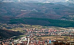
 Panorama of Dimitrovgrad | |
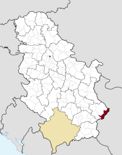
 Location of the municipality of Dimitrovgrad within Serbia | |
| Coordinates: 43°01′N 22°47′E / 43.017°N 22.783°E | |
| Country | |
| Region | Southern and Eastern Serbia |
| District | Pirot |
| Settlements | 43 |
| Government | |
| • Mayor | Vladica Dimitrov (SNS) |
| Area | |
| • Town | 17.15 km2 (6.62 sq mi) |
| • Municipality | 483 km2 (186 sq mi) |
| Elevation | 545 m (1,788 ft) |
| Population (2022 census)[3] | |
| • Town | 5,188 |
| • Town density | 300/km2 (780/sq mi) |
| • Municipality | 8,043 |
| • Municipality density | 17/km2 (43/sq mi) |
| Time zone | UTC+1 (CET) |
| • Summer (DST) | UTC+2 (CEST) |
| Postal code | 18320 |
| Area code | +381(0)10 |
| Car plates | PI |
| Website | www |
Dimitrovgrad (Serbian Cyrillic: Димитровград) alternatively Caribrod (Bulgarian: Цариброд, romanized: Tsaribrod) is a town and municipality located in the Pirot District of southeastern Serbia. According to 2022 census, the municipality has a population of 8,043 and the town has 5,188 inhabitants.[4]
- ^ "Municipalities of Serbia, 2006". Statistical Office of Serbia. Retrieved 2010-11-28.
- ^ "Насеља општине Димитровград" (PDF). stat.gov.rs (in Serbian). Statistical Office of Serbia. Archived from the original (PDF) on 26 January 2021. Retrieved 24 October 2019.
- ^ "2022 Census of Population, Households and Dwellings: Ethnicity (data by municipalities and cities)" (PDF). Statistical Office of Republic Of Serbia, Belgrade. April 2023. ISBN 978-86-6161-228-2. Retrieved 2023-04-30.
- ^ "2022 Census of Population, Households and Dwellings" (PDF). Retrieved 2023-12-07.
© MMXXIII Rich X Search. We shall prevail. All rights reserved. Rich X Search

