Back مورتسيل Arabic Мортсел Bulgarian Mortsel Breton Mortsel Catalan Mortsel (parokya) CEB Mortsel German Mortsel Esperanto Mortsel Spanish Mortsel Basque مرتزل Persian
This article needs additional citations for verification. (March 2014) |
Mortsel | |
|---|---|
City and municipality | |
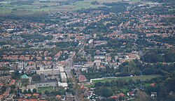
 Aerial view of Mortsel | |
| Coordinates: 51°10′N 04°28′E / 51.167°N 4.467°E | |
| Country | Belgium |
| Community | Flemish Community |
| Region | Flemish Region |
| Province | |
| Arrondissement | Antwerp |
| Government | |
| • Mayor | Erik Broeckx (N-VA) |
| • Governing party/ies | N-VA, Vooruit-I love Mortsel, CD&V |
| Area | |
• Total | 7.78 km2 (3.00 sq mi) |
| Population (2022-01-01)[1] | |
• Total | 26,181 |
| • Density | 3,400/km2 (8,700/sq mi) |
| Postal codes | 2640 |
| NIS code | 11029 |
| Area codes | 03 |
| Website | www.mortsel.be |

Mortsel (Dutch pronunciation: [ˈmɔrtsəl]) is a municipality and city[2] close to the city of Antwerp located in the Belgian province of Antwerp. The municipality only comprises the city of Mortsel proper. In 2021, Mortsel had a total population of 26,170 people. The total area is 7.78 km².[3]
- ^ https://www.ibz.rrn.fgov.be/fileadmin/user_upload/fr/pop/statistiques/population-bevolking-20220101.pdf.
{{cite web}}: Missing or empty|title=(help) - ^ "Wet tot toekenning van de titel van stad aan de gemeenten Genk, Mortsel, Seraing en Waregem". www.ejustice.just.fgov.be (in Dutch). Belgian Official Gazette. 23 June 1999. Retrieved 28 February 2025.
- ^ "Bevolking per statistische sector - Sector 11029". Statistics Belgium. Retrieved 10 May 2022.
© MMXXIII Rich X Search. We shall prevail. All rights reserved. Rich X Search


