Back مقاطعة تشيبيوا (ولاية ويسكونسن) Arabic Chippewa County, Wisconsin BAR Чипъуа (окръг, Уисконсин) Bulgarian চেপেৱা কাউন্টি, উইসকনসিন BPY Chippewa Gông (Wisconsin) CDO Чиппева (гуо, Висконсин) CE Chippewa County (kondado sa Tinipong Bansa, Wisconsin) CEB Chippewa County, Wisconsin Welsh Chippewa County (Wisconsin) German Kantono Chippewa (Viskonsino) Esperanto
Chippewa County | |
|---|---|
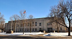
 Chippewa County Courthouse, February 2015 | |
 Location within the U.S. state of Wisconsin | |
 Wisconsin's location within the U.S. | |
| Coordinates: 45°04′N 91°17′W / 45.07°N 91.28°W | |
| Country | |
| State | |
| Founded | 1853 |
| Named for | Ojibwa |
| Seat | Chippewa Falls |
| Largest city | Chippewa Falls |
| Area | |
| • Total | 1,041 sq mi (2,700 km2) |
| • Land | 1,008 sq mi (2,610 km2) |
| • Water | 33 sq mi (90 km2) 3.2% |
| Population | |
| • Total | 66,297 |
| • Density | 65.7/sq mi (25.4/km2) |
| Time zone | UTC−6 (Central) |
| • Summer (DST) | UTC−5 (CDT) |
| Congressional districts | 3rd, 7th |
| Website | www |
Chippewa County is a county located in the U.S. state of Wisconsin. It is named for the historic Chippewa people, also known as the Ojibwe, who long controlled this territory. As of the 2020 census, the population was 66,297.[1] Its county seat is Chippewa Falls.[2] The county was founded in 1845 from Crawford County,[3] then in the Wisconsin Territory, and organized in 1853.[4][5][6]
Chippewa County is included in the Eau Claire, WI Metropolitan Statistical Area as well as the Eau Claire-Menomonie, WI Combined Statistical Area.
- ^ a b Cite error: The named reference
2020-census-55017was invoked but never defined (see the help page). - ^ "Find a County". National Association of Counties. Archived from the original on May 9, 2015. Retrieved June 7, 2011.
- ^ "Early Settlement of West-Central Wisconsin" (PDF). University of Wisconsin-Eau Claire McIntyre Library Special Collections. Archived from the original (PDF) on August 23, 2016. Retrieved November 28, 2016.
- ^ Taken from Wisconsin Blue Book 1991-1992 p. 731; cited there as from "Wisconsin Historical Records, Origin and Legislative History of County Boundaries in Wisconsin, 1942."
- ^ When Counties Originated from rootsweb.com's Oconto County, Wisconsin webpage Archived March 29, 2007, at the Wayback Machine.
- ^ "Wisconsin: Individual County Chronologies". Wisconsin Atlas of Historical County Boundaries. The Newberry Library. 2007. Archived from the original on April 14, 2017. Retrieved August 13, 2015.
© MMXXIII Rich X Search. We shall prevail. All rights reserved. Rich X Search