Back مقاطعة كالامازو (ميتشيغان) Arabic Kalamazoo County, Michigan BAR Каламазу (окръг, Мичиган) Bulgarian কালামাজু কাউন্টি, মিশিগান BPY Comtat de Kalamazoo Catalan Kalamazoo Gông (Michigan) CDO Kalamazoo County CEB Kalamazoo County Czech Kalamazoo County, Michigan Welsh Kalamazoo County German
Kalamazoo County | |
|---|---|
 Kalamazoo County Courthouse | |
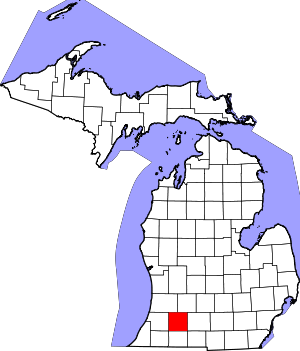
 Location within the U.S. state of Michigan | |
 Michigan's location within the U.S. | |
| Coordinates: 42°14′N 85°32′W / 42.24°N 85.53°W | |
| Country | |
| State | |
| Founded | May 7, 1830[1] |
| Seat | Kalamazoo |
| Largest city | Kalamazoo |
| Area | |
| • Total | 580 sq mi (1,500 km2) |
| • Land | 562 sq mi (1,460 km2) |
| • Water | 19 sq mi (50 km2) 3.2% |
| Population (2020) | |
| • Total | 261,670 |
| • Density | 446/sq mi (172/km2) |
| Time zone | UTC−5 (Eastern) |
| • Summer (DST) | UTC−4 (EDT) |
| Congressional districts | 4th, 5th |
| Website | www |
Kalamazoo County (/ˌkæləməˈzuː/ KAL-ə-mə-ZOO) is a county located in the U.S. state of Michigan. As of 2020[update], the population was 261,670.[2] The county seat is Kalamazoo.[3]
Kalamazoo County is included in the Kalamazoo–Portage, MI Metropolitan Statistical Area.
- ^ Cite error: The named reference
clarkewas invoked but never defined (see the help page). - ^ "QuickFacts". United States Census Bureau. Retrieved September 15, 2021.
- ^ "Find a County". National Association of Counties. Archived from the original on May 31, 2011. Retrieved June 7, 2011.
© MMXXIII Rich X Search. We shall prevail. All rights reserved. Rich X Search