Back مقاطعة لامار (جورجيا) Arabic لامار بؤلگهسی، جورجیا AZB Lamar County, Georgia BAR Ламар (окръг, Джорджия) Bulgarian লামার কাউন্টি, জর্জিয়া BPY Lamar Gông (Georgia) CDO Ламар (гуо, Джорджи) CE Lamar County (kondado sa Tinipong Bansa, Georgia) CEB Lamar County, Georgia Welsh Lamar County (Georgia) German
Lamar County | |
|---|---|
 Lamar County courthouse in Barnesville | |
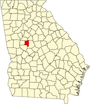
 Location within the U.S. state of Georgia | |
 Georgia's location within the U.S. | |
| Coordinates: 33°04′N 84°08′W / 33.07°N 84.14°W | |
| Country | |
| State | |
| Founded | 1920 |
| Named for | Lucius Quintus Cincinnatus Lamar II |
| Seat | Barnesville |
| Largest city | Barnesville |
| Area | |
| • Total | 186 sq mi (480 km2) |
| • Land | 184 sq mi (480 km2) |
| • Water | 2.3 sq mi (6 km2) 1.3% |
| Population (2020) | |
| • Total | 18,500 |
| • Density | 101/sq mi (39/km2) |
| Time zone | UTC−5 (Eastern) |
| • Summer (DST) | UTC−4 (EDT) |
| Congressional district | 3rd |
| Website | lamarcountyga.com |
Lamar County is a county located in the west central portion of the U.S. state of Georgia. As of the 2020 census, the population was 18,500.[1] The county seat is Barnesville.[2]
- ^ "Census - Geography Profile: Lamar County, Georgia". United States Census Bureau. Retrieved December 27, 2022.
- ^ "Find a County". National Association of Counties. Archived from the original on May 31, 2011. Retrieved June 7, 2011.
© MMXXIII Rich X Search. We shall prevail. All rights reserved. Rich X Search
