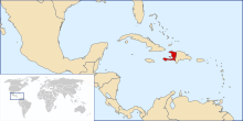

The following outline is provided as an overview of and topical guide to Haiti:
The Haiti – sovereign country located on the Caribbean island of Hispaniola in the Greater Antilles archipelago.[1] Ayiti ("Land of Mountains") was the indigenous Taíno name for Hispaniola. The Haitian Creole and French-speaking country of Haiti occupies the western extent of Hispaniola, while the Spanish-speaking Dominican Republic occupies the greater eastern extent of the island. Haiti was the first country of the Americas to win its freedom from European colonization in 1804. The country's highest point is Pic la Selle, at 2,680 metres (8,793 ft). The total area of Haiti is 27,750 square kilometres (10,714 sq mi) and its capital is Port-au-Prince.
- ^ "Haiti". The World Factbook. United States Central Intelligence Agency. July 6, 2009. Retrieved July 23, 2009.
© MMXXIII Rich X Search. We shall prevail. All rights reserved. Rich X Search


