Back مقاطعة سيمينول (فلوريدا) Arabic سيمينول كاونتى، فلوريدا ARZ Seminol (dairə, Florida) Azerbaijani Seminole County, Florida BAR Семинол (окръг, Флорида) Bulgarian সেমিনোলে কাউন্টি, ফ্লোরিডা BPY Seminole Gông (Florida) CDO Семинол (гуо, Флорида) CE Seminole County (kondado sa Tinipong Bansa, Florida) CEB Seminole County (Florida) Czech
Seminole County | |
|---|---|
County | |
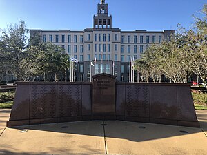
 Fallen Heroes Memorial at the Seminole County Criminal Justice Center | |
 Location within the U.S. state of Florida | |
 Florida's location within the U.S. | |
| Coordinates: 28°43′N 81°14′W / 28.71°N 81.23°W | |
| Country | |
| State | |
| Founded | April 25, 1913 |
| Named for | Seminole people |
| Seat | Sanford |
| Largest city | Sanford |
| Area | |
| • Total | 345 sq mi (890 km2) |
| • Land | 309 sq mi (800 km2) |
| • Water | 36 sq mi (90 km2) 10.4% |
| Population (2020) | |
| • Total | 470,856 |
| • Density | 1,524/sq mi (588.6/km2) |
| Time zone | UTC−5 (Eastern) |
| • Summer (DST) | UTC−4 (EDT) |
| Congressional district | 7th |
| Website | www |
Seminole County (/ˈsɛmɪnoʊl/, SEM-i-nohl) is a county located in the central portion of the U.S. state of Florida. As of the 2020 census, the population was 470,856, making it the 13th-most populated county in Florida.[1][2] Its county seat and largest city is Sanford.[3] Seminole County is part of the Orlando-Kissimmee-Sanford, Florida Metropolitan Statistical Area.
- ^ "State & County QuickFacts". United States Census Bureau. Archived from the original on June 7, 2011. Retrieved June 16, 2014.
- ^ "Florida Counties by Population". Florida Demographics By Cubit. Retrieved February 19, 2023.
- ^ "Find a County". National Association of Counties. Retrieved June 7, 2011.
© MMXXIII Rich X Search. We shall prevail. All rights reserved. Rich X Search

