Back Kabupatén Sigi BAN Kabupatèn Sigi BEW Kabupaten Sigi CEB Sigi (Regierungsbezirk) German Kabupaten Sigi GOR Kabupaten Sigi ID Reggenza di Sigi Italian シギ県 Japanese Kabupatèn Sigi JV Kabupaten Sigi MAP-BMS
Sigi Regency
Kabupaten Sigi | |
|---|---|
| Motto(s): Mareso Masagena (Kaili) (Difficult and Happy to be Together) | |
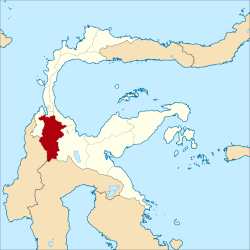
 Location within Central Sulawesi | |
| Coordinates: 1°23′06″S 119°58′01″E / 1.38500°S 119.96694°E | |
| Country | Indonesia |
| Province | Central Sulawesi |
| Capital | Sigi Biromaru |
| Government | |
| • Regent | Mohamad Irwan, S.Sos., M.Si |
| • Vice Regent | Dr. Samuel Yansen Pongi, SE., M.Si |
| Area | |
| • Total | 5,196.02 km2 (2,006.19 sq mi) |
| Population (mid 2023 estimate)[1] | |
| • Total | 266,656 |
| • Density | 51/km2 (130/sq mi) |
| Time zone | UTC+8 (ICST) |
| Area code | (+62) 451 |
| Website | sigikab.go.id |
Sigi Regency is a regency of Central Sulawesi, Indonesia. It was created on 21 July 2008 by splitting off the southern districts from Donggala Regency. It lies upstream on the Palu River, and immediately south of Palu city, the provincial capital. It covers an area of 5,196.02 km2 and had a population of 215,030 at the 2010 Census[2] and 239,421 at the 2020 Census;[3] the official estimate as at mid 2023 was 266,656 (comprising 136,510 males and 130,140 females).[1] The principal town lies at Sigi Biromaru.
Sigi Regency was one of the areas in northwest Sulawesi most affected by the 2018 earthquake and tsunami in Sulawesi. Dozens of people were reported to have been killed by the earthquake and there were reports of "massive liquification" which caused homes to be swept away.


© MMXXIII Rich X Search. We shall prevail. All rights reserved. Rich X Search


