Back مقاطعة يوفالد (تكساس) Arabic Uvalde County, Texas BAR Ювалдэ (акруга) Byelorussian Ювалди (окръг, Тексас) Bulgarian উভালডে কাউন্টি, টেক্সাস BPY Uvalde Gông (Texas) CDO Uvalde County CEB Uvalde County Czech Uvalde County, Texas Welsh Uvalde County German
Uvalde County | |
|---|---|
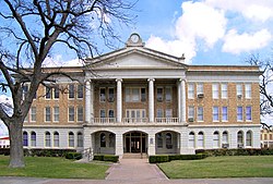
 The Uvalde County Courthouse was built in 1928 in neoclassical design. It is the fifth structure used as the county courthouse, having replaced the previous building constructed in 1890. | |
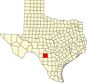
 Location within the U.S. state of Texas | |
 Texas's location within the U.S. | |
| Coordinates: 29°21′N 99°46′W / 29.35°N 99.76°W | |
| Country | |
| State | |
| Founded | 1850 (created) 1856 (organized) |
| Named for | Juan de Ugalde |
| Seat | Uvalde |
| Largest city | Uvalde |
| Area | |
| • Total | 1,559 sq mi (4,040 km2) |
| • Land | 1,552 sq mi (4,020 km2) |
| • Water | 6.7 sq mi (17 km2) 0.4% |
| Population (2020) | |
| • Total | 24,564 |
| • Estimate (2021) | 24,729 |
| • Density | 16/sq mi (6.1/km2) |
| Time zone | UTC−6 (Central) |
| • Summer (DST) | UTC−5 (CDT) |
| Congressional district | 23rd |
| Website | www |
Uvalde County (/juːˈvældi/ yoo-VAL-dee; Spanish: Condado de Uvalde) is a county located in the U.S. state of Texas. As of the 2020 census, its population was 24,564.[1] Its county seat is Uvalde.[2] The county was created in 1850 and organized in 1856.[3] It is named for Juan de Ugalde, the Spanish governor of Coahuila. Uvalde County was founded by Reading Wood Black, who also founded the city of Uvalde, Texas. Uvalde County comprises the Uvalde, TX Micropolitan Statistical Area.
- ^ "State & County QuickFacts". United States Census Bureau. Retrieved March 27, 2022.
- ^ "Find a County". National Association of Counties. Retrieved June 7, 2011.
- ^ "Texas: Individual County Chronologies". Texas Atlas of Historical County Boundaries. The Newberry Library. 2008. Retrieved May 27, 2015.
© MMXXIII Rich X Search. We shall prevail. All rights reserved. Rich X Search