Back مقاطعة وينستون (ألاباما) Arabic Winston County, Alabama BAR Уинстън (окръг, Алабама) Bulgarian উইনস্টন কাউন্টি, আলাবামা BPY Winston Gông (Alabama) CDO Уинстон (гуо, Алабама) CE Winston County (kondado sa Tinipong Bansa, Alabama) CEB Winston County (Alabama) Czech Winston County, Alabama Welsh Winston County (Alabama) German
Winston County | |
|---|---|
 Winston County courthouse in Double Springs | |
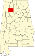
 Location within the U.S. state of Alabama | |
 Alabama's location within the U.S. | |
| Coordinates: 34°08′57″N 87°22′29″W / 34.149166666667°N 87.374722222222°W | |
| Country | |
| State | |
| Founded | February 12, 1850[1] |
| Named for | John A. Winston |
| Seat | Double Springs |
| Largest city | Haleyville |
| Area | |
| • Total | 632 sq mi (1,640 km2) |
| • Land | 613 sq mi (1,590 km2) |
| • Water | 19 sq mi (50 km2) 3.0% |
| Population (2020) | |
| • Total | 23,540 |
| • Estimate (2023) | 23,611 |
| • Density | 37/sq mi (14/km2) |
| Time zone | UTC−6 (Central) |
| • Summer (DST) | UTC−5 (CDT) |
| Congressional district | 4th |
| Website | www |
| |
Winston County is a county of the U.S. state of Alabama. As of the 2020 census, the population was 23,540.[2] Its county seat is Double Springs.[3] Known as Hancock County before 1858,[1] the county is named in honor of John A. Winston, the fifteenth Governor of Alabama.
- ^ a b "ACES Winston County Office" (links/history), Alabama Cooperative Extension System (ACES), 2007, webpage: ACES-Winston.
- ^ "State & County QuickFacts". United States Census Bureau. Retrieved September 10, 2023.
- ^ "Find a County". National Association of Counties. Retrieved June 7, 2011.
© MMXXIII Rich X Search. We shall prevail. All rights reserved. Rich X Search