Back Santorini ALS سانتوريني Arabic جبل سانتورينى ARZ Santorini Azerbaijani Сантарын Byelorussian Санторини Bulgarian Santorini (ostrvo) BS Santorí Catalan Santorini Island CEB Théra (ostrov) Czech
Santorini / Thira
Σαντορίνη / Θήρα | |
|---|---|
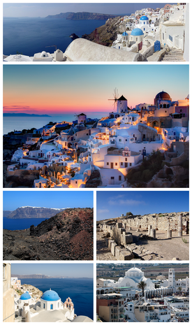 Clockwise from top: Partial panoramic view of Santorini, sunset in the village of Oia, ruins of the Stoa Basilica at Ancient Thera, the Orthodox Metropolitan Cathedral of Ypapanti at the town of Fira, the Aegean Sea as seen from Oia, and view of Fira from the island of Nea Kameni at the Santorini caldera. | |
 Santorini / Thira Location within the region  | |
| Coordinates: 36°24′54″N 25°25′57″E / 36.41500°N 25.43250°E | |
| Country | Greece |
| Administrative region | South Aegean |
| Regional unit | Thira |
| Government | |
| • Mayor | Antonis Sigalas |
| Area | |
| • Municipality | 90.69 km2 (35.02 sq mi) |
| Population (2021)[1] | |
| • Municipality | 15,480 |
| • Density | 170/km2 (440/sq mi) |
| • Municipal unit | 14,393 |
| • Community | 1,516 |
| Time zone | UTC+2 (EET) |
| • Summer (DST) | UTC+3 (EEST) |
| Postal code | 847 00, 847 02 |
| Area code(s) | 22860 |
| Vehicle registration | EM |
| Website | www.thira.gr |

Santorini (Greek: Σαντορίνη, romanized: Santoríni, pronounced [sa(n)doˈrini]), officially Thira (Greek: Θήρα, romanized: Thíra, pronounced [ˈθira]) and Classical Greek Thera (English: /ˈθɪərə/), is an island in the southern Aegean Sea, about 200 km (120 mi) southeast from the Greek mainland. It is the largest island of a small circular archipelago, which bears the same name and is the remnant of a caldera. It is the southernmost member of the Cyclades group of islands, with an area of approximately 73 km2 (28 sq mi) and a 2021 census population of 15,480. The municipality of Santorini includes the inhabited islands of Santorini and Therasia, as well as the uninhabited islands of Nea Kameni, Palaia Kameni, Aspronisi and Christiana. The total land area is 90.623 km2 (34.990 sq mi).[2] Santorini is part of the Thira regional unit.[3]
The island was the site of one of the largest volcanic eruptions in recorded history: the Minoan eruption (sometimes called the Thera eruption), which occurred about 3,600 years ago at the height of the Minoan civilization.[4] The eruption left a large caldera surrounded by volcanic ash deposits hundreds of metres deep.
It is the most active volcanic centre in the South Aegean Volcanic Arc, though what remains today is chiefly a water-filled caldera. The volcanic arc is approximately 500 km (300 mi) long and 20 to 40 km (12 to 25 mi) wide. The region first became volcanically active around 3–4 million years ago,[citation needed] though volcanism on Thera began around 2 million years ago with the extrusion of dacitic lavas from vents around Akrotiri.
- ^ "Αποτελέσματα Απογραφής Πληθυσμού - Κατοικιών 2021, Μόνιμος Πληθυσμός κατά οικισμό" [Results of the 2021 Population - Housing Census, Permanent population by settlement] (in Greek). Hellenic Statistical Authority. 29 March 2024.
- ^ "Population & housing census 2001 (incl. area and average elevation)" (PDF) (in Greek). National Statistical Service of Greece. Archived from the original (PDF) on 2015-09-21.
- ^ "ΦΕΚ A 87/2010, Kallikratis reform law text". Government Gazette (in Greek). Archived from the original on 2021-10-23. Retrieved 2021-09-07.
- ^ Cite error: The named reference
readersnaturalwas invoked but never defined (see the help page).
© MMXXIII Rich X Search. We shall prevail. All rights reserved. Rich X Search