Back نهر هان Arabic نهر هان ARZ Ríu Han AST هان (کره) چایی AZB Ханган Byelorussian Хан (река) Bulgarian হান নদী (কোরিয়া) Bengali/Bangla Riu Han Catalan Han-gang (suba sa Amihanang Koreya) CEB ڕووباری ھان CKB
| Han River | |
|---|---|
 Satellite map of the Han River | |
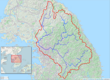
 The Han River watershed | |
| Etymology | Baekje Hanja, "Hansu" (漢水)[a][1] |
| Location | |
| Country | South Korea (KOR), North Korea (PRK) |
| Provinces | Gangwon (KOR), Gyeonggi (KOR), Seoul (KOR), North Hwanghae (PRK) |
| Physical characteristics | |
| Source | Taebaek Mountains |
| • location | Geumdae Peak, Taebaek, Gangwon, South Korea[b][2] |
| Mouth | Yellow Sea |
• location | Northwestern tip of Gimpo peninsula, KOR-PRK border[3] |
| Length | 508 km (316 mi)[4] |
| Basin size | 35,770 km2 (13,810 sq mi)[4] |
| Discharge | |
| • location | Hangang Bridge, Seoul[c][5] |
| • average | 613 m3/s (21,600 cu ft/s)[d][5] |
| Basin features | |
| Tributaries | |
| • left | Dalcheon, Cheongmicheon, Bokhacheon, Gyeongancheon, Anyangcheon, Ara Canal † |
| • right | Seom River, Bukhan River, Jungnangcheon, Gongneungcheon, Rimjin River |
| † : Distributary of Han | |
| Han River | |
| Hangul | 한강 |
|---|---|
| Hanja | |
| Revised Romanization | Han(-)gang |
| McCune–Reischauer | Han'gang |
The Han River or Hangang (Korean: 한강; Korean pronunciation: [ha(ː)n.ɡaŋ])[e] is a major river in South Korea, with some of its tributaries and drainage basin in North Korea. It is the fourth longest river on the Korean peninsula after the Yalu ("Amnok"), Tumen ("Tuman"), and Nakdong rivers.[7] The river begins as two smaller rivers in the eastern mountains of the Korean peninsula, which then converge near Seoul.
The Han River and its surrounding area have played an important role in Korean history. The Three Kingdoms of Korea strove to take control of this land, where the river was used as a trade route to China (via the Yellow Sea).[8] The river is no longer actively used for navigation because its estuary is located at the borders of the two Koreas, and civilian entry is barred.
The river serves as a water source for over 12 million South Koreans. In July 2000, the United States military admitted to having dumped formaldehyde in the sewer system connected to the river, which caused protests.[9]
The lower stretches of the Han River are lined with pedestrian walkways, bicycle paths, public parks and restaurants, particularly in Seoul. In a 2011 survey conducted by Seoul Development Institute of 800 residents and 103 urban planning and architectural experts, 51% of residents and 69% of experts voted the river the second most scenic location in the city, following Mount Namsan in the top spot.[10]
Cite error: There are <ref group=lower-alpha> tags or {{efn}} templates on this page, but the references will not show without a {{reflist|group=lower-alpha}} template or {{notelist}} template (see the help page).
- ^ 2013년 한국하천일람 [List of Rivers of South Korea, 2013] (PDF) (in Korean). Han River Flood Control Office, Republic of Korea. 31 December 2012. pp. 23–24. Archived from the original (PDF) on 4 March 2016. Retrieved 3 July 2014.
{{cite web}}: External link in|publisher= - ^ HRFCO 2012 Archived 2016-03-04 at the Wayback Machine, pp. 25, 28.
- ^ HRFCO 2012 Archived 2016-03-04 at the Wayback Machine, pp. 82-83.
- ^ a b HRFCO 2012 Archived 2016-03-04 at the Wayback Machine, pp. 22, 25, 33, 82-83.
- ^ a b 2014년 1월 월간 수자원 현황 및 전망 [Monthly Status & Predictions Report on Water Resources, January 2014] (in Korean). Han River Flood Control Office, Republic of Korea. 13 January 2014. p. 3. Archived from the original (HWP) on 15 July 2014. Retrieved 15 July 2014.
{{cite web}}: External link in|publisher= - ^ EB (1878), p. 390.
- ^ Shin, Jung-il, "Historic River Flowing through the Korean Peninsula." Koreana (Summer, 2004), 6.
- ^ Liu, William Guanglin (31 August 2015). The Chinese Market Economy, 1000–1500. SUNY Press. ISBN 9781438455679.
- ^ Kirk, Don (15 July 2000). "U.S. Dumping Of Chemical Riles Koreans". The New York Times.
- ^ "Mt. Namsan Picked as Seoul's No. 1 Scenic Attraction". The Chosun Ilbo. 28 April 2011. Retrieved 4 June 2012.
© MMXXIII Rich X Search. We shall prevail. All rights reserved. Rich X Search