Back نهر آيوا Arabic نهر ايوا ARZ Айова (река) Bulgarian আইওয়া নদী Bengali/Bangla Riu Iowa Catalan Iowa River (suba sa Tinipong Bansa) CEB Iowa River Danish Iowa River German Ποταμός Άιοβα Greek Río Iowa Spanish
| Iowa River | |
|---|---|
 The Iowa River upstream of Marshalltown, Iowa | |
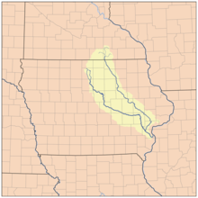
 Map showing the Iowa River (to the left) and its tributary the Cedar River | |
| Location | |
| State | Iowa |
| Physical characteristics | |
| Source | confluence of East Branch Iowa River and West Branch Iowa River |
| • location | Belmond |
| • coordinates | 42°51′38″N 93°36′50″W / 42.860524°N 93.6138214°W |
| Mouth | Mississippi River |
• location | near Toolesboro |
• coordinates | 41°9′38″N 91°1′26″W / 41.16056°N 91.02389°W |
| Length | 323 mi (520 km)[1] |
| Discharge | |
| • location | Oakville, Iowa |
| • average | 14,109 cu/ft. per sec.[2] |
| Basin features | |
| River system | Mississippi River |
| Tributaries | |
| • left | Swisher Creek, Cedar River |
| • right | English River |
The Iowa River is a tributary of the Mississippi River in the state of Iowa in the United States. It is about 323 miles (520 km) long[3] and is open to small river craft to Iowa City, about 65 miles (105 km) from its mouth. Its major tributary is the Cedar River.
- ^ U.S. Geological Survey Geographic Names Information System: Iowa River
- ^ "Iowa River". USGS.
- ^ U.S. Geological Survey. National Hydrography Dataset high-resolution flowline data. The National Map Archived 2012-03-29 at the Wayback Machine, accessed May 13, 2011
© MMXXIII Rich X Search. We shall prevail. All rights reserved. Rich X Search