Back Laki Afrikaans لاكي Arabic Laki AST Лакі Byelorussian Лякі BE-X-OLD Laki Catalan Laki (bolkan) CEB Laki Czech Laki Danish Laki-Krater German
| Laki | |
|---|---|
 | |
| Highest point | |
| Elevation | Varies: canyon to 1,725 m (5,659 ft) |
| Coordinates | 64°03′53″N 18°13′34″W / 64.06472°N 18.22611°W |
| Geography | |
| Geology | |
| Mountain type | Fissure vents |
| Last eruption | 1784 |
 Geological features near the Grímsvötn fissure swarm (red outline). The Laki surface lava flows are shaded violet. Shading also shows: calderas, other central volcanoes, fissure swarms, subglacial terrain above 1,100 m (3,600 ft), and seismically active areas. Clicking on the image enables full window and mouse-over with more detail. | |
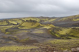
Laki (Icelandic pronunciation: [ˈlaːcɪ] ⓘ) or Lakagígar ([ˈlaːkaˌciːɣar̥], Craters of Laki) is a volcanic fissure in the western part of Vatnajökull National Park, Iceland, not far from the volcanic fissure of Eldgjá and the small village of Kirkjubæjarklaustur. The fissure is properly referred to as Lakagígar, while Laki is a mountain that the fissure bisects. Lakagígar is part of a volcanic system centered on the volcano Grímsvötn and including the volcano Þórðarhyrna.[1][2][3] It lies between the glaciers of Mýrdalsjökull and Vatnajökull, in an area of fissures that run in a southwest to northeast direction.
The system erupted violently over an eight-month period between June 1783 and February 1784 from the Laki fissure and the adjoining volcano Grímsvötn. It poured out an estimated 42 billion tonnes or 14 km3 (18×109 cu yd) of basalt lava as well as clouds of poisonous hydrofluoric acid and sulfur dioxide compounds that contaminated the soil, leading to the death of over 50% of Iceland's livestock population, and the destruction of the vast majority of all crops. This led to a famine which then killed at least a fifth [4] of the island's human population, although some have claimed a quarter. [5]
The Laki eruption and its aftermath caused a drop in global temperatures, as 120 million tonnes of sulfur dioxide was spewed into the Northern Hemisphere. This caused crop failures in Europe and may have caused droughts in North Africa and India.
- ^ "Katla". Global Volcanism Program. Smithsonian Institution. Retrieved March 26, 2010.
- ^ "Iceland : Katla Volcano". Iceland on the web. Retrieved March 26, 2010.
- ^ Gudmundsson, Magnús T.; Thórdís Högnadóttir (January 2007). "Volcanic systems and calderas in the Vatnajökull region, central Iceland: Constraints on crustal structure from gravity data". Journal of Geodynamics. 43 (1): 153–169. Bibcode:2007JGeo...43..153G. doi:10.1016/j.jog.2006.09.015.
- ^ Cite error: The named reference
1783–1784 Laki eruptionwas invoked but never defined (see the help page). - ^ Gunnar Karlsson (2000), Iceland's 1100 Years, p. 181
© MMXXIII Rich X Search. We shall prevail. All rights reserved. Rich X Search
