Back ماداواسكا (مين) Arabic ماداواسكا ARZ Madawaska (Maine) Catalan Мадавоска (Мэн) CE Madawaska (lungsod sa Tinipong Bansa, lat 47,36, long -68,32) CEB Madawaska, Maine Welsh Madawaska (Maine) German Madawaska (Maine) Spanish Madawaska (Maine) Basque Madawaska (Maine) French
Madawaska, Maine
Ville de Madawaska (French) | |
|---|---|
 | |
 Location of Madawaska, Maine | |
| Coordinates: 47°18′25.87″N 68°14′29.69″W / 47.3071861°N 68.2415806°W | |
| Country | United States |
| State | Maine |
| County | Aroostook |
| Incorporated | 1869 |
| Villages | Madawaska Cleveland Fournier Lavertue St. David |
| Area | |
| • Total | 56.24 sq mi (145.66 km2) |
| • Land | 55.56 sq mi (143.90 km2) |
| • Water | 0.68 sq mi (1.76 km2) |
| Elevation | 971 ft (296 m) |
| Population (2020) | |
| • Total | 3,867 |
| • Density | 70/sq mi (26.9/km2) |
| Time zone | UTC-5 (Eastern (EST)) |
| • Summer (DST) | UTC-4 (EDT) |
| ZIP code | 04756 |
| Area code | 207 |
| FIPS code | 23-42520 |
| GNIS feature ID | 0582576 |
| Website | www |
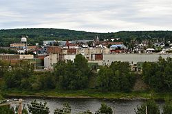
Madawaska is a town in Aroostook County, Maine, United States. The population was 3,867 at the 2020 census.[2] Madawaska is opposite Edmundston, Madawaska County in New Brunswick, Canada, to which it is connected by the Edmundston–Madawaska Bridge over the Saint John River. The majority of its residents speak French; 83.4% of the population speak French at home.
- ^ Cite error: The named reference
Gazetteer fileswas invoked but never defined (see the help page). - ^ "Census - Geography Profile: Madawaska town, Aroostook County, Maine". Retrieved January 15, 2022.
© MMXXIII Rich X Search. We shall prevail. All rights reserved. Rich X Search


