Ovens River

Ovens
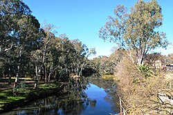
Ovens River at Wangaratta
Course of the Ovens River in Victoria
EtymologyIn honour of Major Ovens, the Secretary to Governor Thomas Brisbane[1]
Native name
Location
CountryAustralia
StateVictoria
RegionAustralian Alps (IBRA), Victorian Alps, Hume
Local government areasAlpine Shire, Wangaratta City, Moira Shire
Towns and citiesHarrietville, Bright, Porepunkah, Myrtleford, Wangaratta
Physical characteristics
SourceGreat Dividing Range
Source confluenceEast and West Branches of the Ovens River
 • locationHarrietville
 • coordinates36°53′15″S 147°3′45″E / 36.88750°S 147.06250°E / -36.88750; 147.06250
 • elevation529 m (1,736 ft)
Mouthconfluence with the Murray River
 • location
near Bundalong
 • coordinates
36°2′15″S 146°10′38″E / 36.03750°S 146.17722°E / -36.03750; 146.17722
 • elevation
125 m (410 ft)
Length191 km (119 mi)
Basin size7,778 km2 (3,003 sq mi)
Discharge 
 • average46 m3/s (1,600 cu ft/s)
Basin features
River systemNorth-East Murray catchment, Murray-Darling basin
Tributaries 
 • leftMorses Creek, Buckland River (Victoria), Buffalo River (Victoria), King River (Victoria)
National parksAlpine NP, Mount Buffalo NP
[4]

The Ovens River, a perennial river of the north-east Murray catchment, part of the Murray-Darling basin, is located in the Alpine and Hume regions of the Australian state of Victoria.

  1. ^ "Ovens River: 23093: Historical Information". Vicnames. 17 June 2011. Archived from the original on 22 June 2014. Retrieved 22 June 2014.
  2. ^ "Ovens River: 23093: Historical Information: Burwang". Vicnames. 12 August 2011. Retrieved 22 June 2014.
  3. ^ "Ovens River: 23093: Historical Information: Djerrang". Vicnames. 12 August 2011. Retrieved 22 June 2014.
  4. ^ "Map of Ovens River". Bonzle Digital Atlas of Australia. Retrieved 22 June 2014.

© MMXXIII Rich X Search. We shall prevail. All rights reserved. Rich X Search