Back كولوميا Arabic كولوميا ARZ کولومیا AZB Коломыя Bashkir Каламыя Byelorussian Каламыя BE-X-OLD Коломия Bulgarian Kolomia Catalan Коломыя CE Kolomyya CEB
Kolomyia
Коломия | |
|---|---|
|
| |
| Coordinates: 48°31′50″N 25°02′25″E / 48.53056°N 25.04028°E | |
| Country | |
| Oblast | |
| Raion | |
| Area | |
| • Total | 41 km2 (16 sq mi) |
| Population (2022) | |
| • Total | 60,821 |
| • Density | 1,494/km2 (3,870/sq mi) |
| Website | www.ko.if.ua City's administrative statistics at Verkhovna Rada web-site[permanent dead link] |
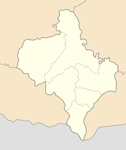
Kolomyia, formerly known as Kolomea (Ukrainian: Коломия, romanized: Kolomyja, pronounced [koɫoˈmɪjɐ] ⓘ; Polish: Kołomyja; German: Kolomea; Romanian: Colomeea; Yiddish: קאָלאָמיי, romanized: Kolomey), is a city located on the Prut River in Ivano-Frankivsk Oblast (province), in western Ukraine. It serves as the administrative centre of Kolomyia Raion (district). The city rests approximately halfway between Ivano-Frankivsk and Chernivtsi, in the centre of the historical region of Pokuttya, with which it shares much of its history. Kolomyia hosts the administration of Kolomyia urban hromada, one of the hromadas of Ukraine.[1] The population is 60,821 (2022 estimate).[2]
The city is a notable railroad hub, as well as an industrial centre (textiles, shoes, metallurgical plant, machine works, wood and paper industry). It is a centre of Hutsul culture. Until 1925 the town was the most populous town in the region. Before the Holocaust about half the town’s population was Jewish.
- ^ "Коломыйская городская громада" (in Russian). Портал об'єднаних громад України.
- ^ Чисельність наявного населення України на 1 січня 2022 [Number of Present Population of Ukraine, as of January 1, 2022] (PDF) (in Ukrainian and English). Kyiv: State Statistics Service of Ukraine. Archived (PDF) from the original on 4 July 2022.
© MMXXIII Rich X Search. We shall prevail. All rights reserved. Rich X Search


